Skip to content

The Next Storm/Next Snow Forecast Discussion from the Cherrywood Observatory – June 17, 2018

This content was originally published by the Longmont Observer and is licensed under a Creative Commons license.

Forecast Discussion:

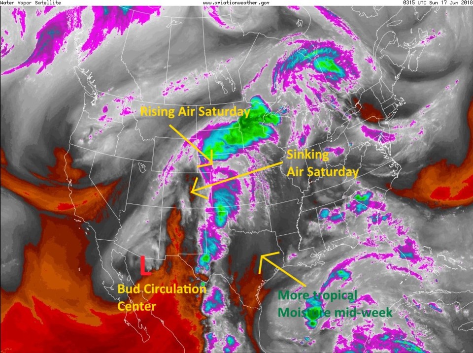
The moisture is arriving, and northern Colorado got dumped on, but Longmont was skipped.  The upper level wave came in a bit early today. By the time daytime heating approached maximum, its lift was off to the east of our part of Colorado (Figure 1). We were in the sinking-air or subsidence side of the trough (sinking air marked). Bud's circulation center is marked with the red L in this figure and is still down on the Mexican border.

Figure 1: the water vapor satellite image from Saturday PM. Reds/Oranges are dry air, greys/whites are moist air regions.

The longer range forecast:

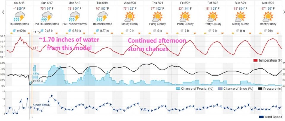
The moisture is still coming and we are expected to still pick up 1 to 2 inches of rainfall by the end of Tuesday by most models. The weatherunderground model still gives us about 1.70 inches of rainfall Sunday afternoon to Tuesday night. Don't give up yet!  (Sunday was always expected to be the big wet day.)

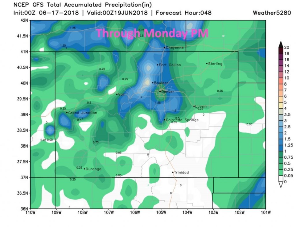
Figure 3 is the GFS through Monday PM - and Longmont receives about 1.25 inches by then.

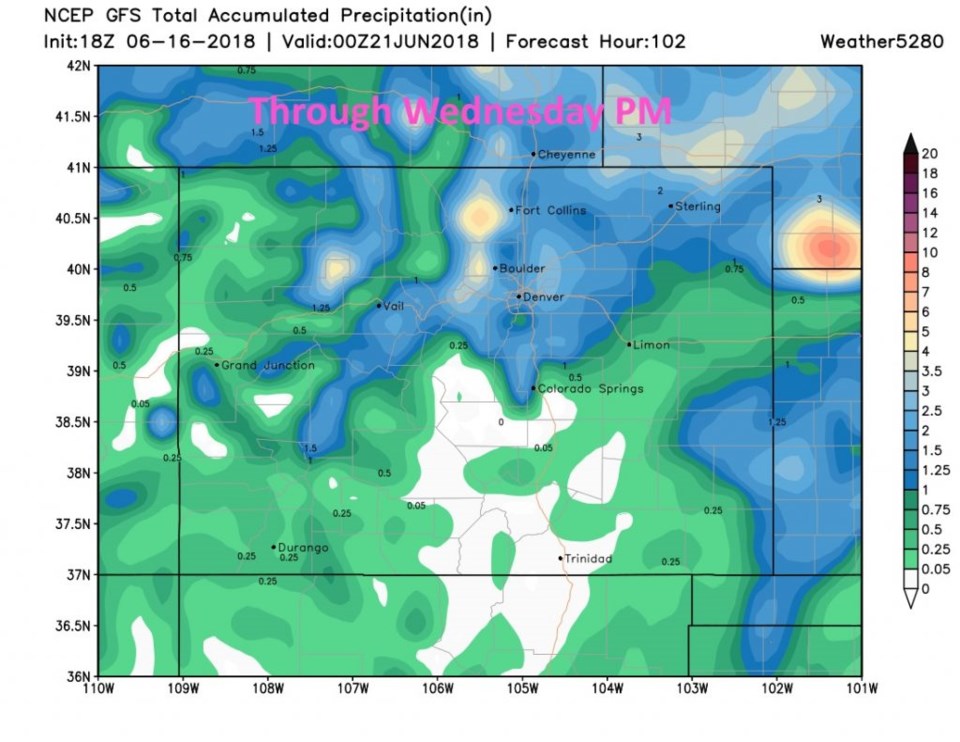
Figure 4 takes the same model out to Wednesday PM and we have picked up just a bit more rain, but there are spots in the foothills that the post front (Sunday) up slope flow will dump up to 4 inches (according to this model).  Sadly, the southwestern part of the state is only seeing a 1/10th to 1/4th inch of rain in most spots. That helps some, but doesn't do what an inch or two would have done for the fire areas (flash flooding chances will be lower though).

More tomorrow... Happy Fathers Day!

Figure 2: the total 10 days of the graphical forecast for Longmont, CO from weatherunderground.com

Figure 3: total precipitation from the GFS between Saturday PM and Monday PM. and weather5280.com.

Figure 4: total precipitation from the GFS between Saturday PM and Wednesday PM. and weather5280.com.

Current Weather

Cloudy

Cloudy

41°F

UV Index
0 Low
Pressure
30.2 Rising
Visibility
8 miles
Dewpoint
30 °F
Humidity
65%
Wind
ESE 1.6 mph
Gust
3.2 mph
Wind Chill
41 °F

Hourly Forecast

Today
7 AM
39°F
Partly sunny
Today
8 AM
42°F
Mostly sunny
Today
9 AM
45°F
Mostly sunny
Today
10 AM
49°F
Mostly sunny
Today
11 AM
53°F
Mostly sunny
Today
12 PM
55°F
Mostly sunny
Today
1 PM
59°F
Mostly sunny
Today
2 PM
61°F
Partly sunny
Today
3 PM
63°F
Partly sunny
Today
4 PM
64°F
Intermittent clouds
Today
5 PM
66°F
Intermittent clouds
Today
6 PM
64°F
Intermittent clouds

7 Day Forecast

Partly sunny

Saturday

66 °F

Partly sunny and not as warm


Mostly clear

Saturday Night

40 °F

Clear to partly cloudy


Mostly cloudy

Sunday

76 °F

Mostly cloudy and warmer; breezy in the afternoon


Mostly cloudy

Sunday Night

47 °F

Rather cloudy; breezy late


Windy

Monday

60 °F

Very windy; cloudy and cooler


Intermittent clouds

Monday Night

43 °F

Partly cloudy


Intermittent clouds

Tuesday

62 °F

Windy with times of clouds and sun


Partly cloudy

Tuesday Night

36 °F

Partly cloudy


Mostly cloudy

Wednesday

60 °F

Turning cloudy


Intermittent clouds

Wednesday Night

35 °F

Partly cloudy


Sunrise and Sunset

Sunrise
5:55 AM
Sunset
7:59 PM

Based on AccuWeather data