Skip to content

The Next Storm/Next Snow Forecast Discussion from the Cherrywood Observatory – May 13, 2018

This content was originally published by the Longmont Observer and is licensed under a Creative Commons license.

Forecast Discussion:

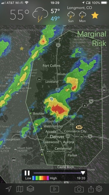
The storm is in progress, but there is still a lot to cover... our first thunderstorm of the weekend rolled through after 7pm (see figure 1). There was small hail south of town.  We are under a marginal risk of severe weather Saturday PM (the darker green outline in figure 1). Because of this, I'll post this Saturday PM rather than Sunday AM.

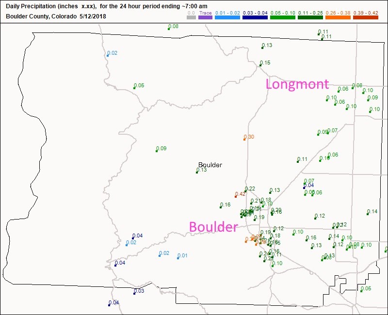
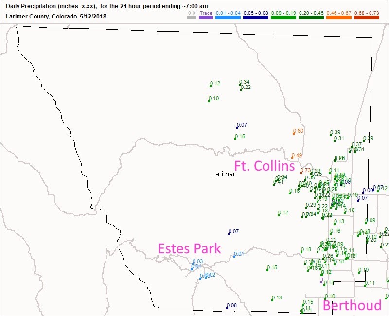
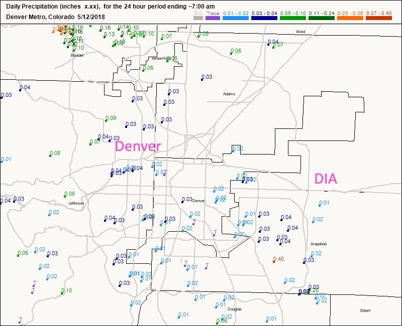
For rainfall totals up to 7am, Figure 2 shows Longmont received about 0.10 inch of rain. Boulder got around 0.2-0.4 inch of rain. Figure 3 shows Ft. Collins received around 0.10 to 0.40 inch of rain. Berthoud got about 0.10 inch of rain. Estes Park only saw a paltry few hundredths of an inch. Figure 4 is the Denver metro which saw a trace to a 0.10 inch of rain. More water fell to the north - as predicted.

Figure 1: Live radar and convective outlook for Saturday PM from My Radar Pro app iOS.

Figure 2: update: the CoCoRaHS precipitation reports for Boulder county by 7am Saturday (the prior 24 hours of accumulation).

Figure 3: update: the CoCoRaHS precipitation reports for Larimaer county by 7am Saturday (the prior 24 hours of accumulation).

Figure 4: update: the CoCoRaHS precipitation reports for Denver Metro by 7am Saturday (the prior 24 hours of accumulation).

The (shorter term) longer range forecast:

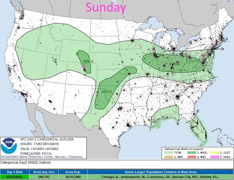
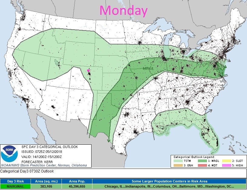
Figure 5 shows there is a marginal risk of severe weather - the primary risk is hail and strong straight line winds- for Sunday.  South Denver could see a weak tornado. For now, figure 6 shows we are back to general thunderstorms on Monday (but we'll see if that remains the case or if that gets upped).

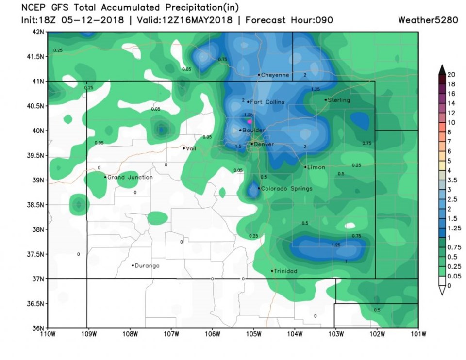
Finally- the rainfall through Wednesday morning, according to the GFS in Figure 7 shows an inch to 1.25 inches of rain is likely nearby though we might be in a notch of less rainfall.  The spacial resolution is such that anything from 0.50 inch to 1.25 inchs is possible in your neighborhood.

More tomorrow!

Figure 5: the day 2 SPC thunderstorm and severe weather forecast made Saturday (valid Sunday).

Figure 6: the day 3 SPC thunderstorm and severe weather forecast made Saturday (valid Monday).

Figure 7: The total precipitation estimate between Saturday PM and Wednesday noon from the GFS and weather5280.com

Current Weather

Light rain

Light rain

42°F

UV Index
0 Low
Pressure
29.93 Rising
Visibility
7 miles
Dewpoint
40 °F
Humidity
93%
Wind
N 3.3 mph
Gust
7.2 mph
Wind Chill
41 °F

Hourly Forecast

Today
6 PM
42°F
Rain and snow
Today
7 PM
41°F
Rain and snow
Today
8 PM
42°F
Rain
Today
9 PM
42°F
Showers
Today
10 PM
41°F
Rain
Today
11 PM
41°F
Rain
Tomorrow
12 AM
41°F
Rain
Tomorrow
1 AM
40°F
Rain
Tomorrow
2 AM
39°F
Rain
Tomorrow
3 AM
39°F
Rain
Tomorrow
4 AM
38°F
Cloudy
Tomorrow
5 AM
37°F
Cloudy

7 Day Forecast

Rain and snow

Saturday

43 °F

Chilly with a mix of snow and rain; travel in the foothills and mountains will be slippery due to snow


Rain and snow

Saturday Night

37 °F

Cloudy with rain, mixed with a little snow late; travel in the foothills and mountains will be slippery due to snow


Thunderstorms

Sunday

61 °F

Mostly cloudy and warmer; a thundershower in spots in the afternoon


Partly cloudy w/ t-storms

Sunday Night

37 °F

A thunderstorm in spots in the evening; otherwise, partly cloudy


Partly sunny

Monday

71 °F

Partly sunny, pleasant and warmer


Intermittent clouds

Monday Night

42 °F

Partly cloudy


Mostly sunny

Tuesday

73 °F

Mostly sunny and pleasant


Mostly cloudy

Tuesday Night

43 °F

Mostly cloudy


Intermittent clouds

Wednesday

65 °F

Times of sun and clouds with a passing shower in the afternoon


Rain

Wednesday Night

42 °F

Overcast; a couple of evening showers followed by rain and drizzle late


Sunrise and Sunset

Sunrise
6:04 AM
Sunset
7:52 PM

Based on AccuWeather data