Skip to content
Join our Newsletter

The Next Storm/Next Snow Forecast Discussion from the Cherrywood Observatory – May 14, 2018

This content was originally published by the Longmont Observer and is licensed under a Creative Commons license.

Forecast Discussion:

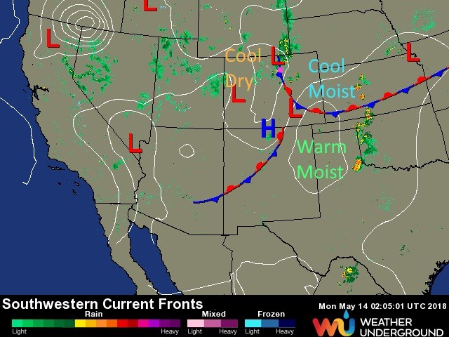
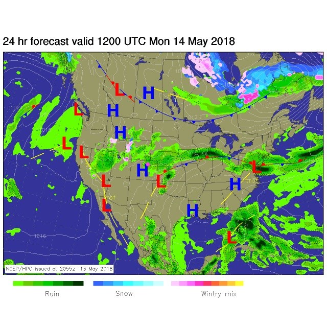
The stormy weekend rages on (well in the evenings at least).  There are lows forming and moving on and reforming on the Plains, a stationary front that is draped down the Rockies and stretching east-west near the Palmer Divide or as far south as the Raton Plateau at times.  This has cool, often foggy, drizzly weather in the northeastern part of the state, warm moist air down south and cool dry air out west (figure 1). Very interesting, and stagnant, pattern (as we saw with the upper air pattern halting and drifting a bit west over this time period before filling in).

Short waves coming down the stream (jet stream) are kicking off afternoon thunderstorms (when surface heating is at a maximum) giving us great thunderstorms Sunday PM and some small hail.

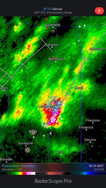
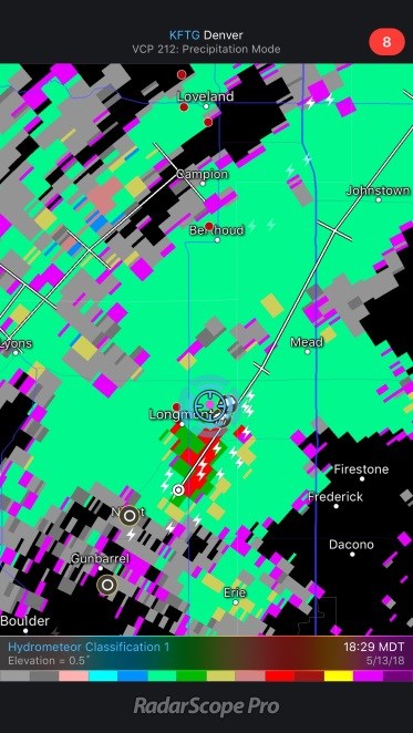
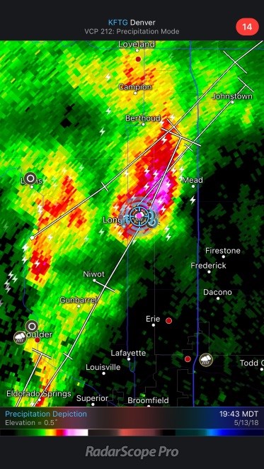
Figure 2 is the cell that moved by around 6:30pm Sunday. Figure 3 is a radar product that tries to tell the difference between rain, snow, hail and other combinations and types.  The red colors are hail and rain mixed. Storms 'trained' (multiple cells passing over the same locations like boxcars on a train) over Longmont into the mid evening. Figure 4 is another cell at 7:45pm that hit us with pea sized hail around NE Longmont. I am at over 1.1 inches of rainfall since Thursday in NE Longmont, total.

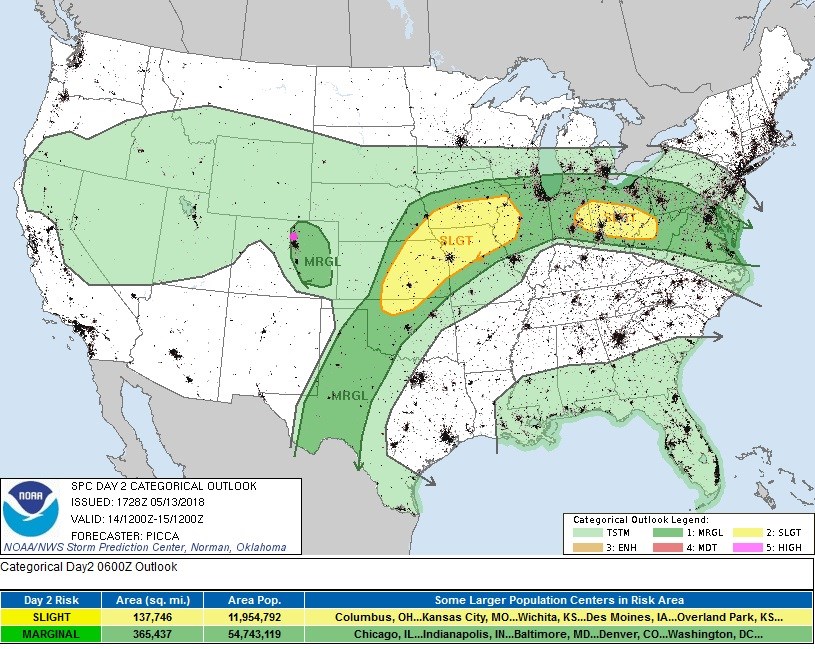
Today, the situation repeats with fog/drizzle in the morning (easterly up slope flow) followed by thunderstorms in the afternoon.  Figure 5 is the surface forecast for the morning. Figure 6 is the SPC thunderstorm forecast for the afternoon. We are under a marginal risk of severe weather again (small hail and strong winds and localized flooding are the risks).

Figure 1: the current surface map analysis Sunday PM from weatherunderground.com

Figure 2: Radar image from 6:30pm Sunday from RadarScope Pro iOS app.

Figure 3: Radar image hydrometeor classification from 6:30pm Sunday from RadarScope Pro iOS app.

Figure 4: Radar image from 7:45pm Sunday from RadarScope Pro iOS app.

Figure 5: forecast surface analysis for Monday morning from NCEP.

Figure 6: the day 2 SPC thunderstorm and severe weather forecast made Sunday (valid Monday).

The longer range forecast:

We warm a touch tomorrow but have another day with afternoon thunderstorms (and probably another marginal risk of severe weather issued as we get closer).  We dry out a bit on Wednesday and Thursday then rain and thunderstorms return for Friday into the weekend.  More later!

Figure 7: the next few days snippet of the 10 day graphical forecast for Longmont from weatherunderground.com

Current Weather

Clear

Clear

74°F

UV Index
0 Low
Pressure
29.66 Steady
Visibility
9 miles
Dewpoint
31 °F
Humidity
20%
Wind
S 3.9 mph
Gust
7.8 mph
Wind Chill
74 °F

Hourly Forecast

Today
2 AM
73°F
Clear
Today
3 AM
70°F
Clear
Today
4 AM
68°F
Clear
Today
5 AM
66°F
Clear
Today
6 AM
65°F
Sunny
Today
7 AM
68°F
Sunny
Today
8 AM
74°F
Sunny
Today
9 AM
80°F
Sunny
Today
10 AM
83°F
Sunny
Today
11 AM
86°F
Sunny
Today
12 PM
88°F
Sunny
Today
1 PM
90°F
Mostly sunny

7 Day Forecast

Sunny

Saturday

100 °F

Sunny and hot with the temperature approaching the record of 103 set in 2016; gusty winds, low humidity and dry brush result in a high fire threat


Clear

Saturday Night

65 °F

Clear and mild


Mostly sunny

Sunday

94 °F

Sunny to partly cloudy; breezy this afternoon; gusty winds, low humidity and dry brush result in a high fire threat


Mostly clear

Sunday Night

54 °F

Breezy this evening; otherwise, mainly clear


Mostly cloudy

Monday

78 °F

Rather cloudy and cooler


Mostly cloudy w/ t-storms

Monday Night

55 °F

A couple of evening showers and a thunderstorm; otherwise, partly to mostly cloudy


Intermittent clouds

Tuesday

80 °F

Intervals of clouds and sunshine with a thunderstorm in spots in the afternoon


Mostly cloudy

Tuesday Night

60 °F

Overcast in the evening; partly cloudy late


Partly sunny w/ t-storms

Wednesday

75 °F

Intervals of clouds and sunshine with a couple of showers and a thunderstorm


Mostly clear

Wednesday Night

54 °F

Clear to partly cloudy


Sunrise and Sunset

Sunrise
5:31 AM
Sunset
8:33 PM

Based on AccuWeather data