Skip to content

The Next Storm/Next Snow Forecast Discussion from the Cherrywood Observatory – May 24, 2018

This content was originally published by the Longmont Observer and is licensed under a Creative Commons license.

Forecast Discussion:

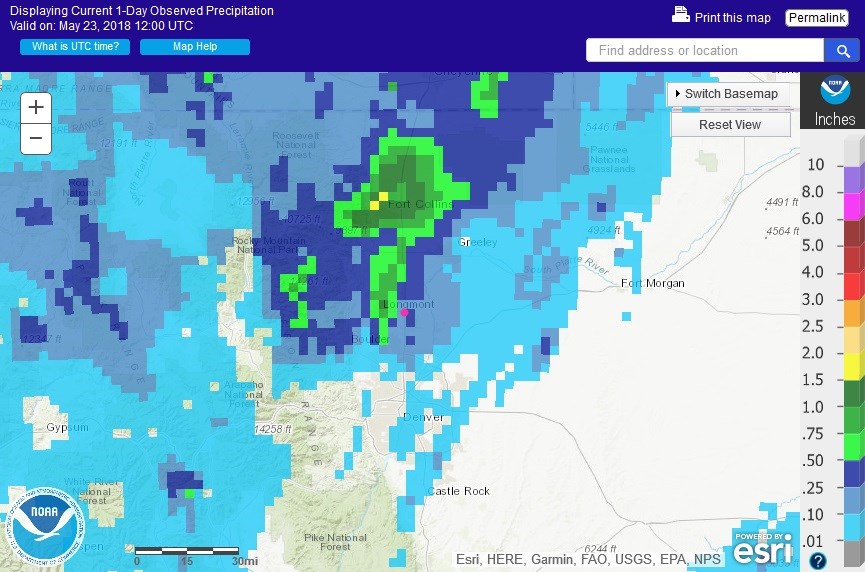
We had nice thunderstorms yesterday!  The marginal risk was justified.  The total precipitation was about 2/3rds of an inch in two waves, but a good area of Colorado from west of town up beyond Ft. Collins picked up 3/4ths to 1.5 inches of rain (Figure 1). I experienced about 20 minutes of pea sized hail during the storms.  Parts of Berthoud had small hail drifts.

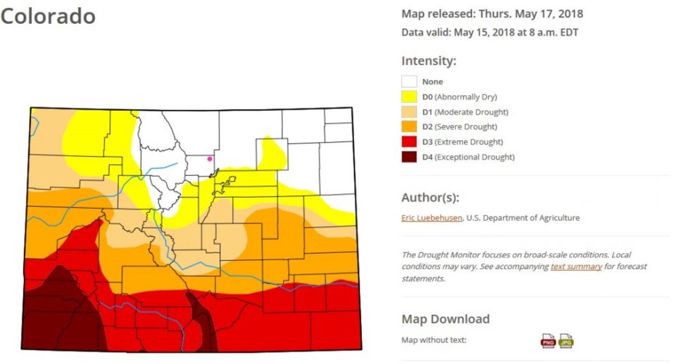
Figure 2 is the drought monitor graphic from last week.  We'll watch for changes when they next update this.  Boulder county and most of NE Colorado are not experiencing any drought conditions.  Extreme drought and worse are still found in the southern 1/4th of the state.  Send rain!

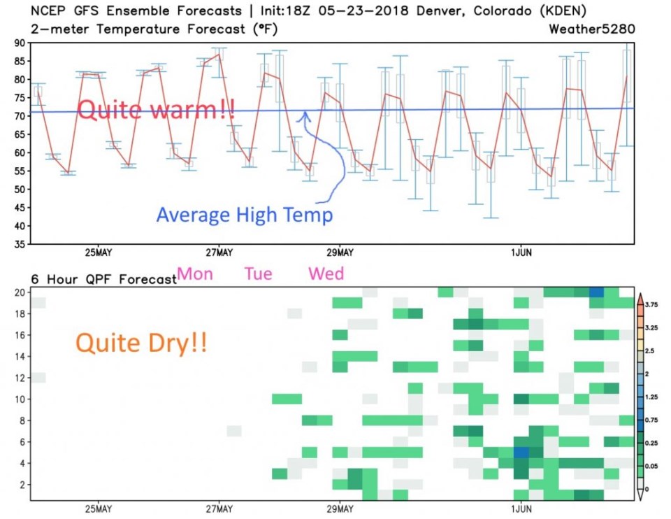
Things get very quiet and dry into the weekend (for a change). See the long term for details...

Figure 1: The 1 day precipitation total for north central Colorado from NOAA and esri.

Figure 2: The drought index from last Thursday (prior to more rain) from the U.S. Dept. of Ag.

The long range forecast:

Let's look out over the next 10 days.  Our normal high is still in the lower 70'sF, but we'll be pushing closer and closer to 90F into the weekend before another trough approaches and cools us.  There are VERY low chances of rain until mid-next week (Figure 3). You get a strong dose of mid- to late summer for whatever pool activities you want to get into for the Memorial Day weekend.

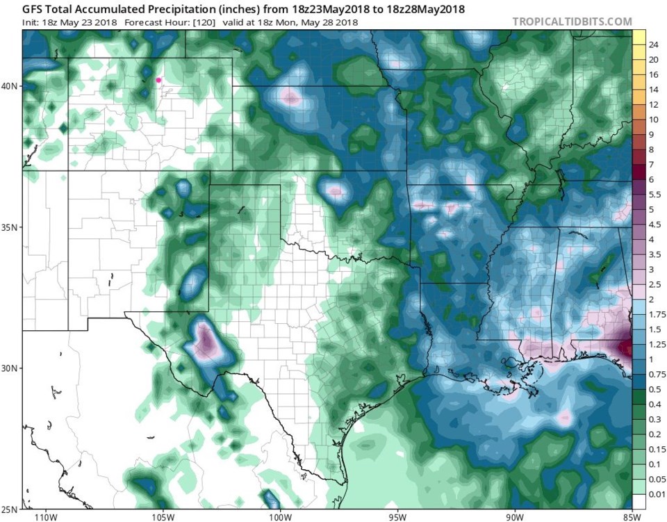
The total precipitation for Colorado over the next 5 days (from the GFS too, Figure 4) doesn't give Longmont much of anything. The high mountains may see brief buildups that dump some rain in the afternoons.  Summer time weather!!

Figure 3: The 10 day GFS graphical forecast and precipitation ensemble.

Figure 4: The GFS forecasted accumulated precipitation up to Monday May 28th midday.

Current Weather

Cloudy

Cloudy

47°F

UV Index
2 Low
Pressure
30.19 Falling
Visibility
8 miles
Dewpoint
28 °F
Humidity
48%
Wind
SE 2.9 mph
Gust
6.2 mph
Wind Chill
46 °F

Hourly Forecast

Today
11 AM
50°F
Partly sunny
Today
12 PM
54°F
Mostly sunny
Today
1 PM
58°F
Mostly sunny
Today
2 PM
61°F
Partly sunny
Today
3 PM
63°F
Partly sunny
Today
4 PM
65°F
Intermittent clouds
Today
5 PM
66°F
Intermittent clouds
Today
6 PM
65°F
Intermittent clouds
Today
7 PM
63°F
Intermittent clouds
Today
8 PM
60°F
Mostly clear
Today
9 PM
57°F
Mostly clear
Today
10 PM
55°F
Mostly clear

7 Day Forecast

Intermittent clouds

Saturday

66 °F

Not as warm with intervals of clouds and sunshine


Mostly clear

Saturday Night

39 °F

Clear to partly cloudy


Mostly cloudy

Sunday

77 °F

Mostly cloudy and warmer; breezy in the afternoon


Mostly cloudy

Sunday Night

45 °F

Rather cloudy; breezy late


Windy

Monday

60 °F

Very windy; cloudy and cooler


Intermittent clouds

Monday Night

43 °F

Partly cloudy


Intermittent clouds

Tuesday

62 °F

Times of clouds and sun; windy in the afternoon


Partly cloudy

Tuesday Night

36 °F

Partly cloudy


Intermittent clouds

Wednesday

60 °F

Times of clouds and sun


Intermittent clouds

Wednesday Night

35 °F

Partly cloudy


Sunrise and Sunset

Sunrise
5:55 AM
Sunset
7:59 PM

Based on AccuWeather data