Skip to content

The Next Storm/Next Snow Forecast Discussion from the Cherrywood Observatory – May 26, 2018

This content was originally published by the Longmont Observer and is licensed under a Creative Commons license.

Forecast Discussion:

I'm on travel today (holiday weekend!).  Many of you may be on travel as well, so I'll be brief...

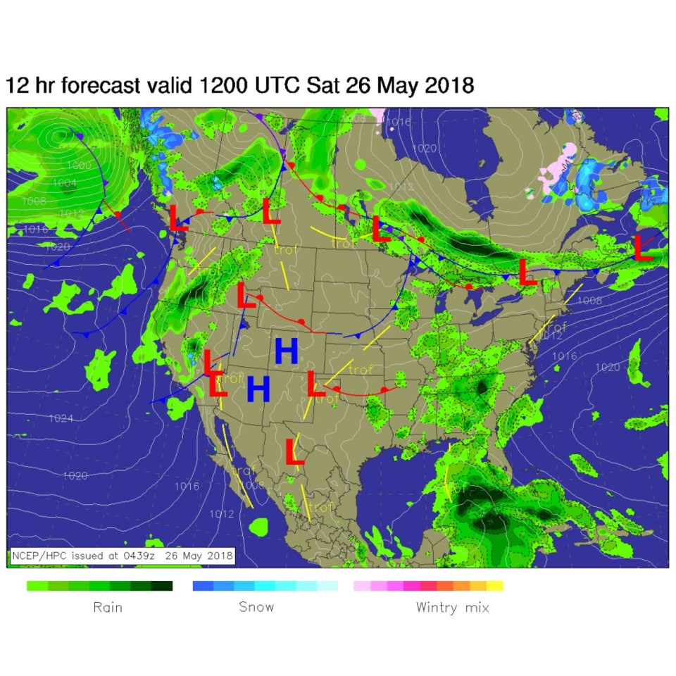
The hottest of the hottest (maybe 95F in Longmont) is hitting today. We still have a surface high pressure center over the state at the surface.  We are ahead of a cool front and sooth of a warm front (seen in Figure 1).

Chances of thunderstorms are very close to 0% today with all the warm aloft.

Figure 1: The forecast surface analysis map for Saturday AM from NCEP.

The longer range forecast:

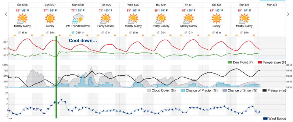
We would rocket into the 90'sF again tomorrow if that cool front didn't arrive in the afternoon. I've drawn a green line through the point that temperatures drop, dew points (wiggly horizontal green line), when clouds and a chance of rain returns, and winds pick up and come out of the northeast (Figure 2).

Beyond that, afternoon chances of rain are back and thunderstorms are expected (from this model) on Memorial Day. The SPC (not shown) does not have a chance of even normal thunderstorms over Longmont on Monday.  They forecast thunderstorms for Greeley and Firestone etc. but not back on this side of I-25.  We'll see.

Looking farther out, we warm up a bit and have afternoon thunderstorms possible almost every day.   Alberto (that just formed in the Gulf of Mexico, won't effect the weather here directly, but I'll look into covering it a bit tomorrow if it intensifies.)

Figure 2: The 10 day graphical forecast for Longmont from weatherunderground.com

Current Weather

Cloudy

Cloudy

40°F

UV Index
0 Low
Pressure
30.18 Steady
Visibility
8 miles
Dewpoint
30 °F
Humidity
66%
Wind
SSE 1.6 mph
Gust
3.8 mph
Wind Chill
40 °F

Hourly Forecast

Today
6 AM
37°F
Mostly cloudy
Today
7 AM
39°F
Partly sunny
Today
8 AM
42°F
Mostly sunny
Today
9 AM
45°F
Mostly sunny
Today
10 AM
49°F
Mostly sunny
Today
11 AM
53°F
Mostly sunny
Today
12 PM
55°F
Mostly sunny
Today
1 PM
59°F
Mostly sunny
Today
2 PM
61°F
Partly sunny
Today
3 PM
63°F
Partly sunny
Today
4 PM
64°F
Intermittent clouds
Today
5 PM
66°F
Intermittent clouds

7 Day Forecast

Partly sunny

Saturday

66 °F

Partly sunny and not as warm


Mostly clear

Saturday Night

40 °F

Clear to partly cloudy


Mostly cloudy

Sunday

76 °F

Mostly cloudy and warmer; breezy in the afternoon


Mostly cloudy

Sunday Night

47 °F

Rather cloudy; breezy late


Windy

Monday

60 °F

Very windy; cloudy and cooler


Intermittent clouds

Monday Night

43 °F

Partly cloudy


Intermittent clouds

Tuesday

62 °F

Windy with times of clouds and sun


Partly cloudy

Tuesday Night

36 °F

Partly cloudy


Mostly cloudy

Wednesday

60 °F

Turning cloudy


Intermittent clouds

Wednesday Night

35 °F

Partly cloudy


Sunrise and Sunset

Sunrise
5:55 AM
Sunset
7:59 PM

Based on AccuWeather data