Skip to content

The Next Storm/Next Snow Forecast Discussion from the Cherrywood Observatory – October 11th, 2018

This content was originally published by the Longmont Observer and is licensed under a Creative Commons license.

Forecast Discussion:

Snow has fallen most of the day Wednesday with some accumulation on cold surfaces before sunrise and again in the afternoon when snow rates increased. We had enough moisture to create puddles! (Take that GFS, you were wrong.)

The surface map shows one front passing back to the east while a cool air mass is still pushed down to the south. When there is a front over the state, we can see up-slope flow and showers from passing upper level short waves. Rain chances don't vanish today even though things warm up and dry out a bit (Figure 1).

We approach 60°F tomorrow/Friday, then the next system sets up...
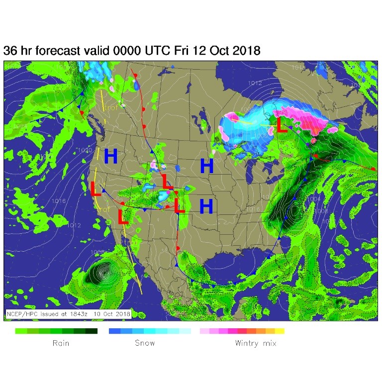
Figure 1: The forecast surface map for Thursday p.m.. From NCEP.

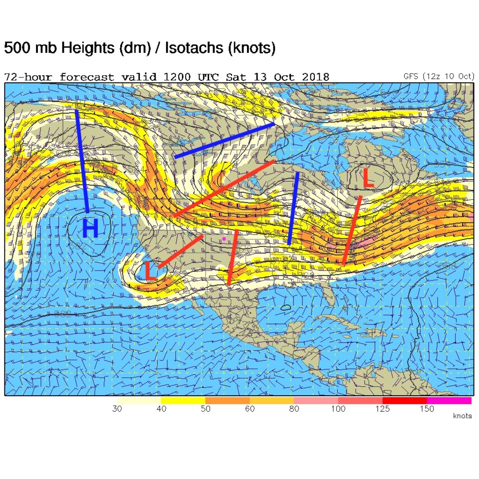
Figure 2: The 500mb forecast upper air analysis for Saturday a.m.. Pink dot is Longmont. Red lines are troughs, blue lines are ridges.

The longer range forecast:

Our next cold front enters the state Saturday afternoon after about 3 p.m. Before that, we'll have a high up at about 60°F again. Temperatures keep dropping through the night to drop below freezing before midnight. Temperatures won't go above freezing again until about 11 a.m. Monday. With that front, very cold air (a high of 30°F on Sunday!!), we are expecting more snow.

The GFS (Figure 3) gives us about 4-5 inches.

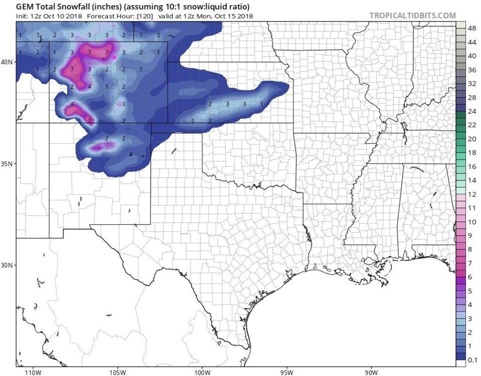
The GEM (Figure 4) gives us 4-5 inches.

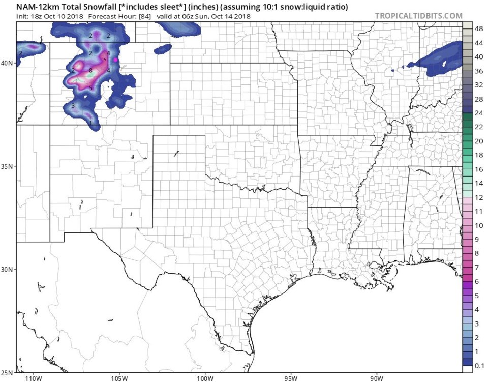
The NAM (Figure 5) gives us 1-3 inches (up through midnight Sat-Sun, so not the whole storm).

The weatherunderground model gives us 2-6 inches. It seems like a consensus!

Prepare for a Saturday p.m. to Sunday snow.
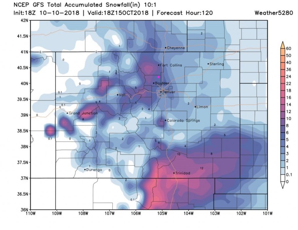
Figure 3: The total snowfall accumulation from Wednesday p.m. up to noon Monday from the GFS model and weather5280.com

Figure 4: The total snowfall accumulation from Wednesday p.m. up to noon Monday from the GFS model and weather5280.com

Figure 5: The total snowfall accumulation from Wednesday p.m. up to late night Saturday from the NAM model and weather5280.com

Current Weather

Sunny

Sunny

42°F

UV Index
2 Low
Pressure
30.02 Rising
Visibility
8 miles
Dewpoint
27 °F
Humidity
55%
Wind
SSE 3.2 mph
Gust
6.9 mph
Wind Chill
41 °F

Hourly Forecast

Today
9 AM
47°F
Mostly sunny
Today
10 AM
51°F
Mostly sunny
Today
11 AM
55°F
Mostly sunny
Today
12 PM
58°F
Mostly sunny
Today
1 PM
60°F
Partly sunny
Today
2 PM
62°F
Intermittent clouds
Today
3 PM
63°F
Mostly cloudy
Today
4 PM
64°F
Mostly cloudy
Today
5 PM
63°F
Cloudy
Today
6 PM
61°F
Cloudy
Today
7 PM
58°F
Mostly cloudy
Today
8 PM
55°F
Mostly cloudy

7 Day Forecast

Intermittent clouds

Thursday

64 °F

A blend of sun and clouds; breezy this afternoon


Mostly cloudy

Thursday Night

35 °F

Mostly cloudy


Partly sunny

Friday

68 °F

Increasingly windy with partial sunshine


Partly cloudy

Friday Night

38 °F

Partly cloudy


Partly sunny

Saturday

66 °F

Partial sunshine


Mostly clear

Saturday Night

41 °F

Clear to partly cloudy


Mostly cloudy

Sunday

78 °F

Rather cloudy and warmer; windy in the afternoon


Intermittent clouds

Sunday Night

43 °F

Partly cloudy; windy late


Mostly cloudy

Monday

60 °F

Mostly cloudy, breezy and cooler


Mostly cloudy

Monday Night

43 °F

Mostly cloudy


Sunrise and Sunset

Sunrise
5:58 AM
Sunset
7:57 PM

Based on AccuWeather data