Skip to content

Update 3pm: The Next Storm/Next Snow Forecast Discussion from the Cherrywood Observatory – October 14th, 2018

This content was originally published by the Longmont Observer and is licensed under a Creative Commons license.

Forecast Discussion:

The storm is underway so I'll post later today.  Right now (after midnight) the high end snow totals, towards 5 or even 6 inches of snow is more likely for Longmont.  I drove home from the airport at 1am and it was a rough drive!

More later today!

Update 3:00pm

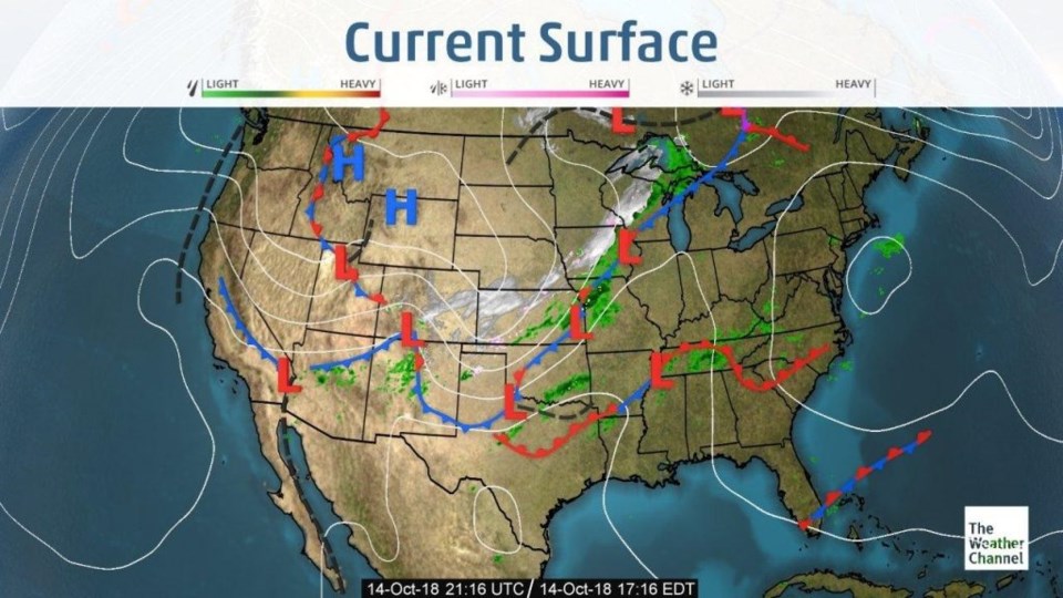
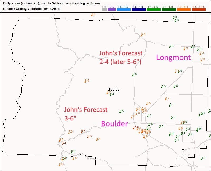
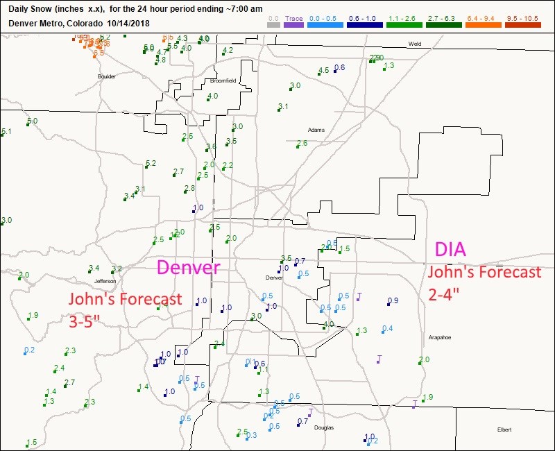
The storm is winding down mid-afternoon Sunday (Figure 1). The storm over-performed for areas north of Denver (but the storm was still ongoing and sinking south at the reporting time of 7am).  I inserted my forecast in red next to the actual up-to-7am reports.  Figure 2 is Boulder county - Longmont saw 5-8 inches.  Boulder received 5-10 inches.

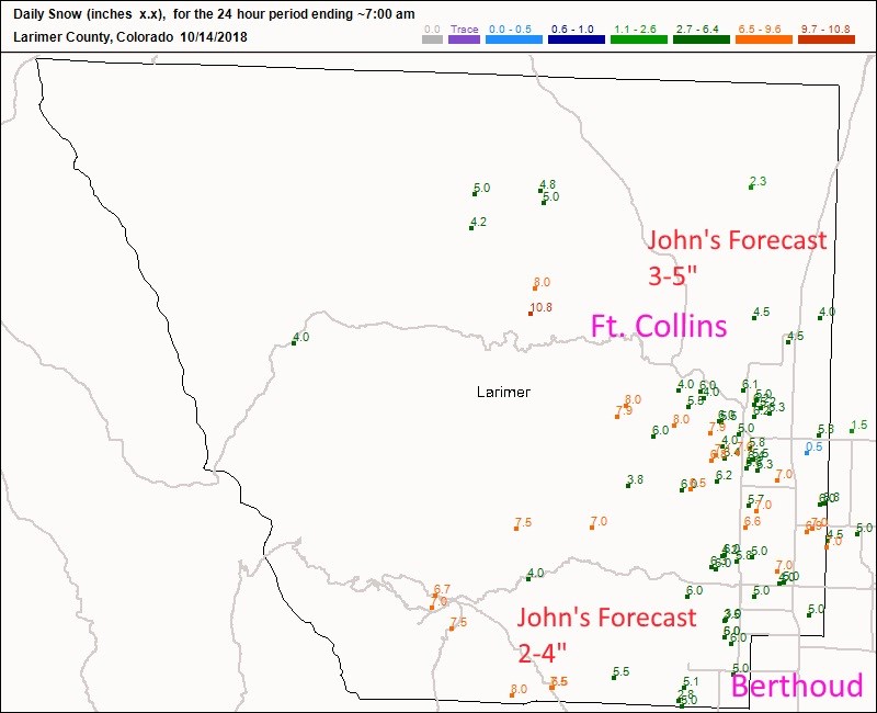
Figure 3 shows Boulder receiving 4-8 inches while Estes park saw 6-8 inches and Berthoud picked up 3-5 inches.  Figure 4 is the Denver Metro (where the snow was still coming down heavily) only had a few inches across the city.  More tomorrow on the later snow totals.

Figure 1: The current surface map for Sunday afternoon from the Weather Channel.

Figure 2: The CoCoRaHS snowfall reports up to 7am Sunday (the storm continued to roughly 1pm) for Boulder County.

Figure 3: The CoCoRaHS snowfall reports up to 7am Sunday (the storm continued to roughly 1pm) for Larimer County.

Figure 4: The CoCoRaHS snowfall reports up to 7am Sunday (the storm continued to roughly 1pm) for Denver Metro.

The longer range forecast:

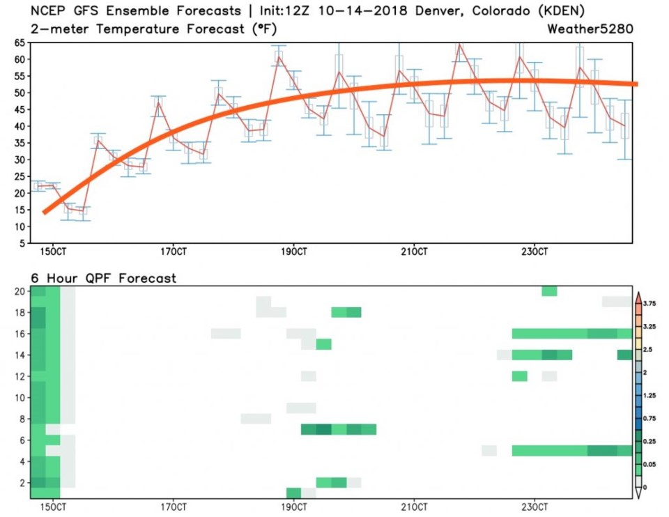
The weather becomes almost completely dry again (just a few model runs have slight rain chances this week - Figure 5) after today.  Temperatures begin a steady climb to around 60-65F for highs and level off.  Quietness will rule.   The 10/15 update will be posted midday when the new storm totals come in.

** A reminder, this column will take it's first full break for a family vacation from Friday Oct 26 to Nov 4th.  **

Figure 5: 10 day meteogram from weather5280.com for DIA.

Current Weather

Mostly cloudy

Mostly cloudy

74°F

UV Index
3 Moderate
Pressure
29.81 Rising
Visibility
13 miles
Dewpoint
24 °F
Humidity
15%
Wind
W 7 mph
Gust
18.3 mph
Wind Chill
74 °F

Hourly Forecast

Today
4 PM
70°F
Partly sunny
Today
5 PM
65°F
Partly sunny w/ showers
Today
6 PM
60°F
Partly sunny
Today
7 PM
55°F
Partly sunny
Today
8 PM
52°F
Partly cloudy
Today
9 PM
49°F
Partly cloudy
Today
10 PM
47°F
Partly cloudy
Today
11 PM
44°F
Partly cloudy
Tomorrow
12 AM
43°F
Partly cloudy
Tomorrow
1 AM
42°F
Partly cloudy
Tomorrow
2 AM
41°F
Partly cloudy w/ showers
Tomorrow
3 AM
39°F
Partly cloudy

7 Day Forecast

Partly sunny w/ showers

Friday

76 °F

More sunshine than clouds; breezy this afternoon with a shower in spots


Partly cloudy w/ showers

Friday Night

37 °F

Partly cloudy with a couple of showers late


Partly sunny

Saturday

66 °F

Sun and some clouds


Mostly clear

Saturday Night

40 °F

Clear to partly cloudy


Mostly cloudy

Sunday

76 °F

Mostly cloudy and warmer; breezy in the afternoon


Mostly cloudy

Sunday Night

51 °F

Rather cloudy; windy late


Windy

Monday

60 °F

Winds gusting past 40 mph; cloudy and cooler


Intermittent clouds

Monday Night

43 °F

Breezy in the evening; otherwise, partly cloudy


Intermittent clouds

Tuesday

62 °F

Times of clouds and sun; windy in the afternoon


Intermittent clouds

Tuesday Night

36 °F

Clearing


Sunrise and Sunset

Sunrise
5:57 AM
Sunset
7:58 PM

Based on AccuWeather data