Skip to content

The Next Storm/Next Snow Forecast Discussion from the Cherrywood Observatory – October 15th, 2018

This content was originally published by the Longmont Observer and is licensed under a Creative Commons license.

Forecast Discussion:

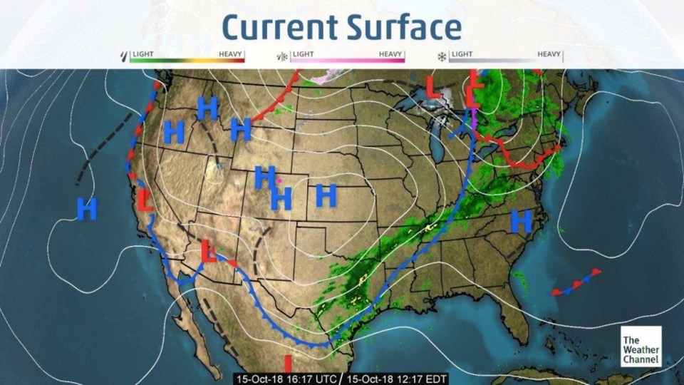
I'm issuing an extreme mild advisory for today and the next week. The upper level trough is pulling off to the east as surface high pressure builds in over the entire region (Figure 1). We dropped to around 10°F this morning, but we climb about 15°F over the next 24 hours.

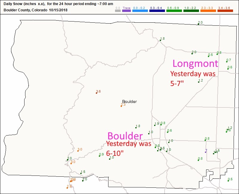
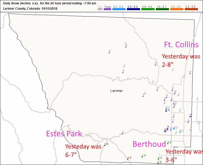
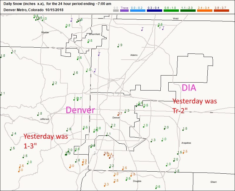
To catch up on snowfall reports since 7 a.m. yesterday, Figure 2 shows Longmont picked up another 1/2 inch or so, Boulder received another 1/2 to 2 inches. Figure 3 shows that Ft. Collins only got a dusting more. Estes park almost received another 2 inches while Berthoud received 1/2 to 2 inches more as well. Finally (Figure 4) southwestern Colorado picked up 2-3 inches more and the airport received 1/2 to 2 inches around the region.

Figure 1: The current surface map for Sunday afternoon from the Weather Channel.

Figure 2: The CoCoRaHS snowfall reports up to 7 a.m. Monday (the storm continued to roughly 1 p.m.) for Boulder County.

Figure 3: The CoCoRaHS snowfall reports up to 7 a.m. Monday (the storm continued to roughly 1 p.m.) for Larimer County.

Figure 4: The CoCoRaHS snowfall reports up to 7 a.m. Monday (the storm continued to roughly 1 p.m.) for the Metro Denver.

The longer range forecast:

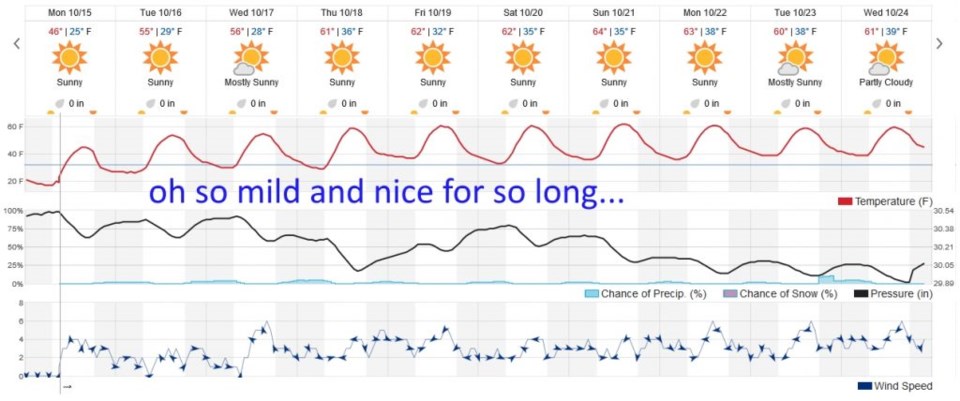
It will warm a bit and stay dry for the next 10 days or more (Figure 5). Too bad this stretch didn't occur when I go on vacation (there will be no updates to this column for the period October 26-Nov 4).

Figure 5: the next 10 days of the graphical forecast for Longmont, CO from weatherunderground.com

Current Weather

Light rain

Light rain

41°F

UV Index
1 Low
Pressure
29.9 Rising
Visibility
6 miles
Dewpoint
39 °F
Humidity
91%
Wind
N 3.6 mph
Gust
8.2 mph
Wind Chill
38 °F

Hourly Forecast

Today
11 AM
39°F
Rain
Today
12 PM
39°F
Rain
Today
1 PM
40°F
Rain
Today
2 PM
40°F
Cloudy
Today
3 PM
41°F
Rain
Today
4 PM
41°F
Rain
Today
5 PM
42°F
Cloudy
Today
6 PM
42°F
Rain
Today
7 PM
42°F
Rain
Today
8 PM
41°F
Rain
Today
9 PM
41°F
Cloudy
Today
10 PM
40°F
Rain

7 Day Forecast

Rain

Saturday

42 °F

Chilly with rain and a thunderstorm, some heavy early in the day; travel in the foothills and mountains will be slippery due to snow


Rain and snow

Saturday Night

36 °F

Cloudy with rain, mixed with a little snow late; travel in the foothills and mountains will be slippery due to snow


Thunderstorms

Sunday

60 °F

Mostly cloudy and warmer; a thundershower in spots in the afternoon


Partly cloudy w/ t-storms

Sunday Night

37 °F

A thunderstorm in spots in the evening; otherwise, partly cloudy


Partly sunny

Monday

71 °F

Partly sunny, pleasant and warmer


Intermittent clouds

Monday Night

42 °F

Partly cloudy


Mostly sunny

Tuesday

73 °F

Mostly sunny; pleasant in the afternoon


Mostly cloudy

Tuesday Night

40 °F

Mostly cloudy


Intermittent clouds

Wednesday

65 °F

Times of sun and clouds with a passing shower in the afternoon


Rain

Wednesday Night

35 °F

Overcast; a couple of evening showers followed by rain and drizzle late


Sunrise and Sunset

Sunrise
6:04 AM
Sunset
7:52 PM

Based on AccuWeather data