Skip to content

The Next Storm/Next Snow Forecast Discussion from the Cherrywood Observatory – October 4th, 2018

This content was originally published by the Longmont Observer and is licensed under a Creative Commons license.

Forecast Discussion:

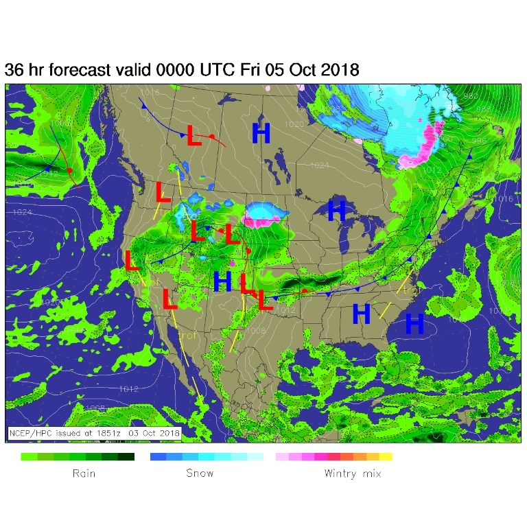
We made up for not hitting 80F for the last few days by hitting 87F with strong down slope winds as the front approached. By tonight, the front will be draped somewhere east of I-25 with widespread showers possible over the entire state (Figure 1). All this instability is driven by the approaching upper level trough with a shortwave embedded in it to boot (smaller red trough line east of the main trough axis, Figure 2).

Figure 1: The forecast surface map for Thursday PMon. From NCEP.

Figure 2: The 500mb forecast upper air analysis for Thursday AM. Pink dot is Longmont. Red lines are troughs, blue lines are ridges.

The longer range forecast:

In Figure 3, I've drawn the 70F line in mustard, 60F in teal, 50F in violet and the freezing line in magenta.  This is an average, so though the error bars extend beyond freezing, the mean stays warmer than that magical, plant killing, temperature.  As for rainfall (the bottom panel) we have 3 distinct storm events over the next 3 days, then it becomes a messy confusing long-range period of daily rain chances.  What a change!

Looking at rainfall totals, the weatherunderground.com model gives us 0.60" through Sunday and a total of 1.10" of rain over the next 10 days.

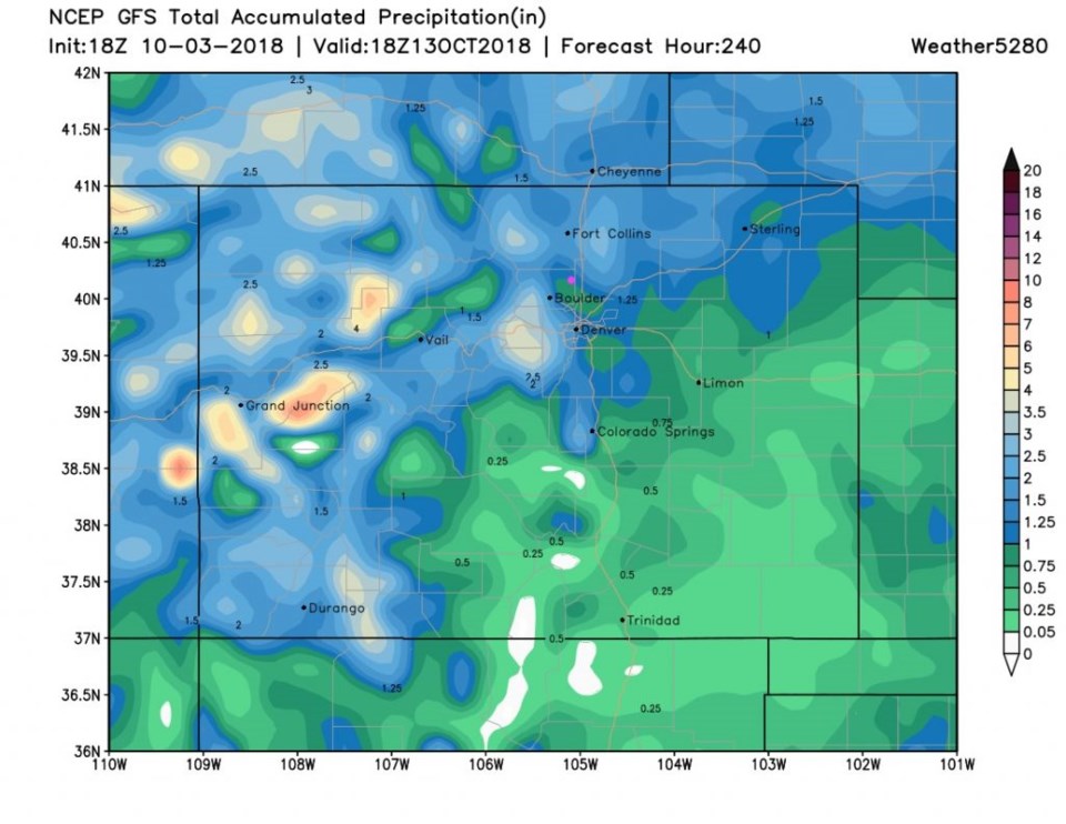
Figure 4 is the GFS through Sunday and it looks like about 0.25 to 0.50".

Figure 5 is the GFS over the next 10 days and it is about 1.00 to 1.25".  They agree!

Figure 3: 10 day meteogram from weather5280.com for DIA.

Figure 4: The total precipitation between Wednesday PM and Sunday PM from the GFS and weather5280.com

Figure 5: The total precipitation for the next 10 days between Wednesday PM and Saturday 10/13 noon from the GFS and weather5280.com

Current Weather

Mostly cloudy

Mostly cloudy

62°F

UV Index
1 Low
Pressure
29.86 Steady
Visibility
8 miles
Dewpoint
35 °F
Humidity
35%
Wind
W 3.2 mph
Gust
8.6 mph
Wind Chill
62 °F

Hourly Forecast

Today
6 PM
61°F
Thunderstorms
Today
7 PM
58°F
Intermittent clouds
Today
8 PM
54°F
Intermittent clouds
Today
9 PM
51°F
Intermittent clouds
Today
10 PM
48°F
Intermittent clouds
Today
11 PM
45°F
Intermittent clouds
Tomorrow
12 AM
44°F
Partly cloudy
Tomorrow
1 AM
42°F
Partly cloudy
Tomorrow
2 AM
41°F
Partly cloudy
Tomorrow
3 AM
40°F
Partly cloudy
Tomorrow
4 AM
39°F
Partly cloudy
Tomorrow
5 AM
38°F
Partly cloudy

7 Day Forecast

Partly sunny w/ t-storms

Sunday

64 °F

Warmer with times of clouds and sun; a thundershower in spots late this afternoon


Intermittent clouds

Sunday Night

37 °F

Partly cloudy


Partly sunny

Monday

70 °F

Partly sunny and pleasant


Intermittent clouds

Monday Night

43 °F

Partly cloudy


Mostly sunny

Tuesday

73 °F

Mostly sunny and pleasant


Intermittent clouds

Tuesday Night

41 °F

Clearing


Intermittent clouds

Wednesday

65 °F

Times of sun and clouds


Intermittent clouds

Wednesday Night

39 °F

A thundershower in spots in the evening; otherwise, partly cloudy


Rain

Thursday

53 °F

Cooler with occasional rain and drizzle; breezy in the morning


Partly cloudy

Thursday Night

32 °F

Partly cloudy


Sunrise and Sunset

Sunrise
6:03 AM
Sunset
7:53 PM

Based on AccuWeather data