Skip to content

The Next Storm/Next Snow Forecast Discussion from the Cherrywood Observatory – September 11th, 2018

This content was originally published by the Longmont Observer and is licensed under a Creative Commons license.

Forecast Discussion:

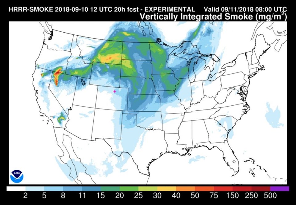
With a big ridge over the middle nation, we have bone dry weather with near record to record high temperatures expected much of the rest of this week. Figure 1 shows that big ridge axis to our east with southwest flow locally. That flow is bringing in clearer air (with some smoke and haze stuck in the downwind side of the Rockies - Figure 2). That's all I've got to say about our home town.

Let's look out into the future for the next cool down and off to the East Coast and Florence...

Figure 1: The 500mb forecast upper air analysis for Tuesday noon. Pink dot is Longmont. Red lines are troughs, blue lines are ridges. From weather5280.com

Figure 2: The HRRR (high resolution rapid refresh) model forecast of smoke at all levels for Tuesday early AM.

The longer range forecast:

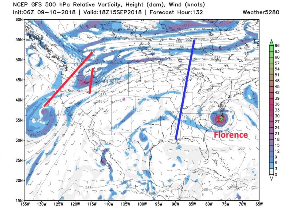
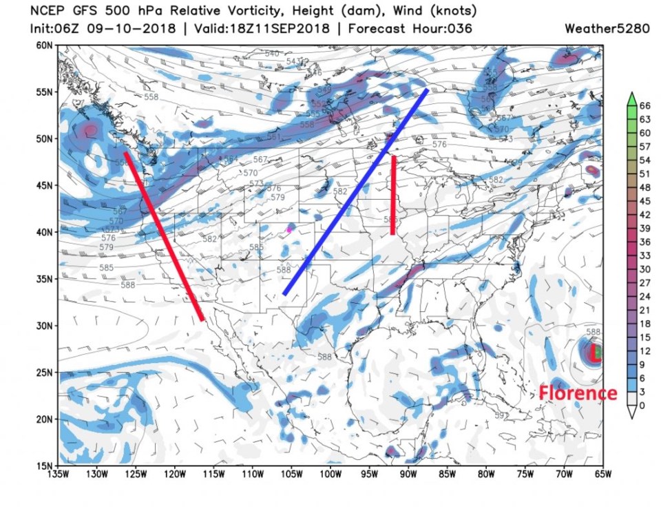
The 500mb map for Saturday afternoon is shown in Figure 3. The ridge axis shifts east to possibly trap Florence in North Carolina and Virginia (more on this below) but the ridge is still holding strong in the western U.S. as well. A narrow trough is hanging out on the West coast with short waves breaking off and traveling up into Canada over the ridge. That is quite a blob of high pressure!

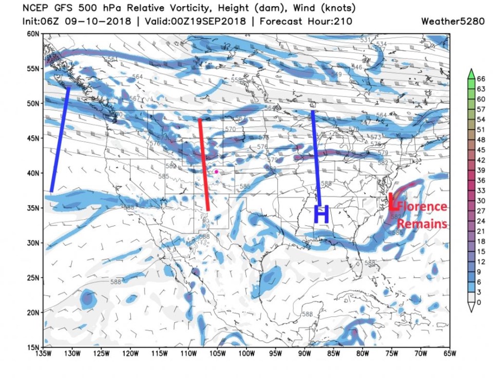
The next trough that will push in appears to approach Monday/Tuesday next week (Figure 4). We have a while to wait for that possible taste of Fall. Note that moisture from Florence is still hanging out around North Carolina and Virginia into the middle of next week.

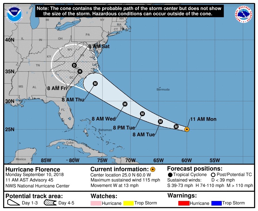
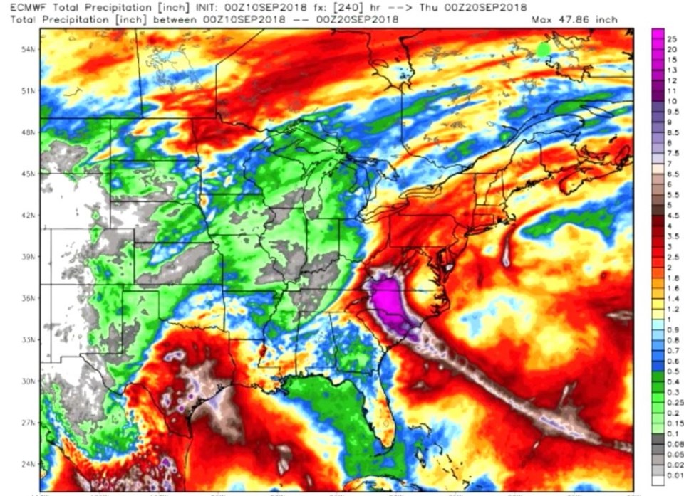
The current National Hurricane Center (NOAA) forecast for Hurricane Florence (Figure 5) shows that southern and central parts of North Carolina are under the gun for the storm's damage. The landfall spot is looking like it will be located along the northern South Carolina coast or southern North Carolina coast (at category 4 strength). With the storm coming in as the big U.S. ridge rocks east, it might lose its steering winds abruptly, sit, spin, die, and dump rain over SC, NC, and western VA. Figure 6 (if it verifies) shows a wide area of 20-48 inches of rainfall. Some forecasters are rightfully describing that outcome as the greatest potential disaster for the region in recorded history. Please keep an eye on it if you know of anyone living in those states.

That is not the only hit the U.S. is expecting either... Hurricane Olivia is expected to hit the Hawaiian Islands (as it weakens) Tuesday night/Wednesday morning with torrential rainfall on the mountain slopes. According to WeatherBell forecaster Joe Bastardi, though, after the next week or two, he expects the tropics to calm down a lot with El Niño effects showing up. That is a ray of hope!

Figure 3: The 500mb forecast upper air analysis for Saturday noon. Pink dot is Longmont. Red lines are troughs, blue lines are ridges. From weather5280.com

Figure 4: The 500mb forecast upper air analysis for next Tuesday night (9/18). Pink dot is Longmont. Red lines are troughs, blue lines are ridges. From weather5280.com

Figure 5: the five day cone of uncertainty plot forecast from the NHC for Florence.

Figure 6: The total precipitation predicted by the ECMWF model for the next 10 days from weatherbell.com public video. Max value in the purple region is 47.86 inches.

Current Weather

Cloudy

Cloudy

44°F

UV Index
0 Low
Pressure
29.79 Steady
Visibility
7 miles
Dewpoint
41 °F
Humidity
90%
Wind
NW 3.8 mph
Gust
6.5 mph
Wind Chill
42 °F

Hourly Forecast

Today
1 AM
45°F
Cloudy
Today
2 AM
44°F
Cloudy
Today
3 AM
44°F
Rain
Today
4 AM
44°F
Cloudy
Today
5 AM
44°F
Rain
Today
6 AM
44°F
Rain
Today
7 AM
44°F
Rain
Today
8 AM
43°F
Cloudy
Today
9 AM
42°F
Rain
Today
10 AM
41°F
Rain
Today
11 AM
41°F
Rain
Today
12 PM
40°F
Rain

7 Day Forecast

Mostly cloudy w/ t-storms

Friday

69 °F

Variable cloudiness with a couple of thundershowers this afternoon; gusty winds and small hail can accompany any downpour


Thunderstorms

Friday Night

41 °F

Cloudy; showers and thunderstorms this evening followed by periods of rain late; gusty winds and small hail can accompany any downpour


Rain

Saturday

44 °F

Chilly with periods of rain and a thunderstorm; travel in the foothills and mountains will be slippery due to snow


Rain and snow

Saturday Night

36 °F

Cloudy with rain, mixed with a little snow late; travel in the foothills and mountains will be slippery due to snow


Mostly cloudy

Sunday

61 °F

Mostly cloudy and warmer


Intermittent clouds

Sunday Night

36 °F

A thunderstorm in spots in the evening; otherwise, partly cloudy


Partly sunny

Monday

71 °F

Partly sunny, pleasant and warmer


Partly cloudy

Monday Night

45 °F

Partly cloudy


Mostly sunny

Tuesday

73 °F

Pleasant with sunshine and patchy clouds


Partly cloudy

Tuesday Night

40 °F

Partly cloudy


Sunrise and Sunset

Sunrise
6:06 AM
Sunset
7:51 PM

Based on AccuWeather data