Skip to content

The Next Storm/Next Snow Forecast Discussion from the Cherrywood Observatory – September 13th, 2018

This content was originally published by the Longmont Observer and is licensed under a Creative Commons license.

Forecast Discussion:

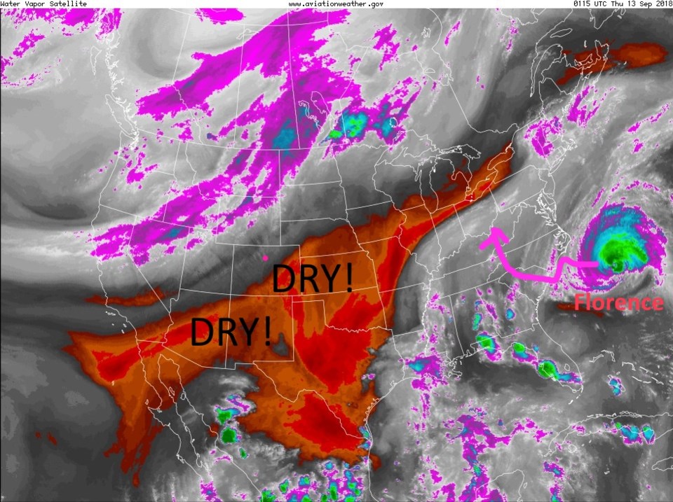
The ridge still rules, the atmosphere is dry, there is no smoke in the state, and a cool down is visible - 8 days out from now.

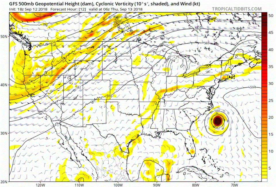
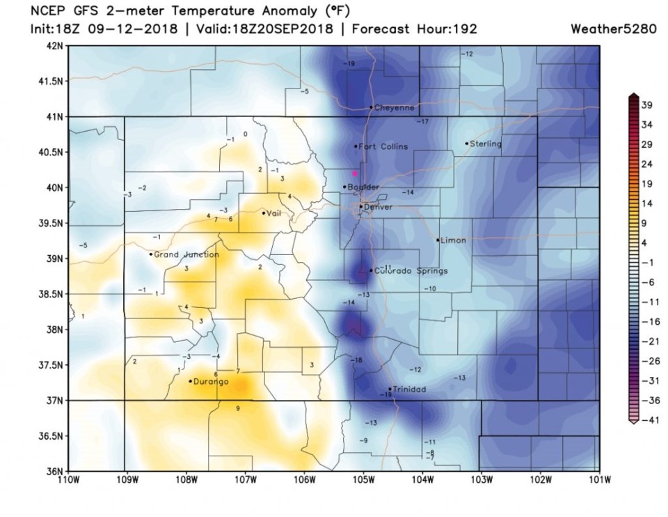
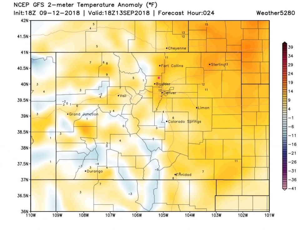
Figure 1 shows the dry weather on this side of the stationary west coast trough (purple is center of moist axis). The surface map for later today shows dry conditions and high pressure over Colorado (Figure 2). The temperatures will continue to be about 10-13F above average (Figure 3). Toasty!

Figure 1: the water vapor satellite image from Wednesday afternoon. Reds/Oranges are dry air, greys/whites are moist air regions.

Figure 2: The forecast surface map for Thursday PM. From NCEP.

Figure 3: the departure from normal temperature at noon Thursday - surface temperatures from weather5280.com

The longer range forecast:

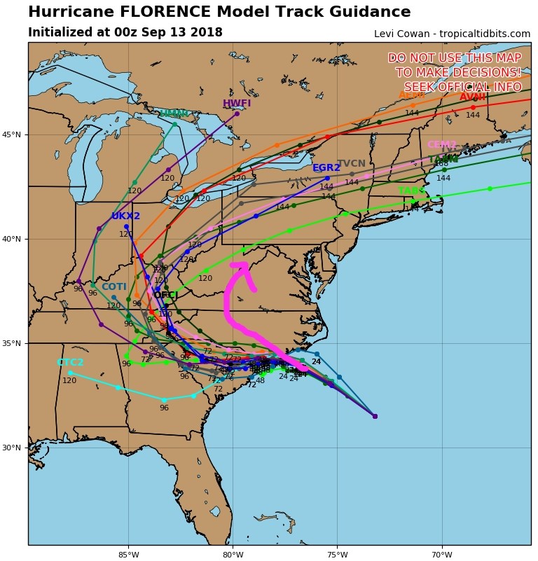
Figure 4 is the animation of the upper air pattern showing Colorado sitting under the same pattern for most of the next week.  You can see Florence drift in, die inland and zip off to the northeast on this run of the GFS. Finally, about 7 days out, you can see the ridge modify and break down. Troughs start to enter the West.

The first big cold front roars into the state the early morning of Thursday the 20th (Figure 5).  That is a 30F drop from the week between now and then.

Looking at Florence, there is coverage of this storm everywhere now, and is often updated more frequently than this column as landfall is hours away.  Figure 6 shows the push-me-pull-me of the two highs will now result in the storm drifting VERY slowly to the southwest for 48 hours or more before heading deep inland to die.  Some folks in the Carolina's will see feet of rain. The tangle of models all pretty much agree.  The pink arrow in Figure 7 is the approx. location of the earlier path.  That is quite a southward drift!!

Figure 4: The animated 500mb forecast upper air analysis for next 9 days. from tropicaltidbits.com

Figure 5: the departure from normal temperature at noon Thursday next week 9/20- surface temperatures from weather5280.com

Figure 6: the five day cone of uncertainty plot forecast from the NHC for Florence.

Figure 7: the five day multi model plot forecast from the NHC for Florence.

Current Weather

Light rain

Light rain

41°F

UV Index
1 Low
Pressure
29.91 Steady
Visibility
5 miles
Dewpoint
38 °F
Humidity
90%
Wind
N 3.9 mph
Gust
7.3 mph
Wind Chill
38 °F

Hourly Forecast

Today
4 PM
42°F
Rain
Today
5 PM
42°F
Cloudy
Today
6 PM
42°F
Rain and snow
Today
7 PM
41°F
Rain and snow
Today
8 PM
42°F
Rain
Today
9 PM
42°F
Showers
Today
10 PM
41°F
Rain
Today
11 PM
41°F
Rain
Tomorrow
12 AM
41°F
Rain
Tomorrow
1 AM
40°F
Rain
Tomorrow
2 AM
39°F
Rain
Tomorrow
3 AM
39°F
Rain

7 Day Forecast

Rain and snow

Saturday

42 °F

Chilly with a mix of snow and rain; travel in the foothills and mountains will be slippery due to snow


Rain and snow

Saturday Night

37 °F

Cloudy with rain, mixed with a little snow late; travel in the foothills and mountains will be slippery due to snow


Thunderstorms

Sunday

61 °F

Mostly cloudy and warmer; a thundershower in spots in the afternoon


Partly cloudy w/ t-storms

Sunday Night

37 °F

A thunderstorm in spots in the evening; otherwise, partly cloudy


Partly sunny

Monday

71 °F

Partly sunny, pleasant and warmer


Intermittent clouds

Monday Night

42 °F

Partly cloudy


Mostly sunny

Tuesday

73 °F

Mostly sunny and pleasant


Mostly cloudy

Tuesday Night

43 °F

Mostly cloudy


Intermittent clouds

Wednesday

65 °F

Times of sun and clouds with a passing shower in the afternoon


Rain

Wednesday Night

42 °F

Overcast; a couple of evening showers followed by rain and drizzle late


Sunrise and Sunset

Sunrise
6:04 AM
Sunset
7:52 PM

Based on AccuWeather data