Skip to content

The Next Storm/Next Snow Forecast Discussion from the Cherrywood Observatory – September 15th, 2018

This content was originally published by the Longmont Observer and is licensed under a Creative Commons license.

Forecast Discussion:

The heat goes on!  (How many more of these catchy phrases can I come up with?)

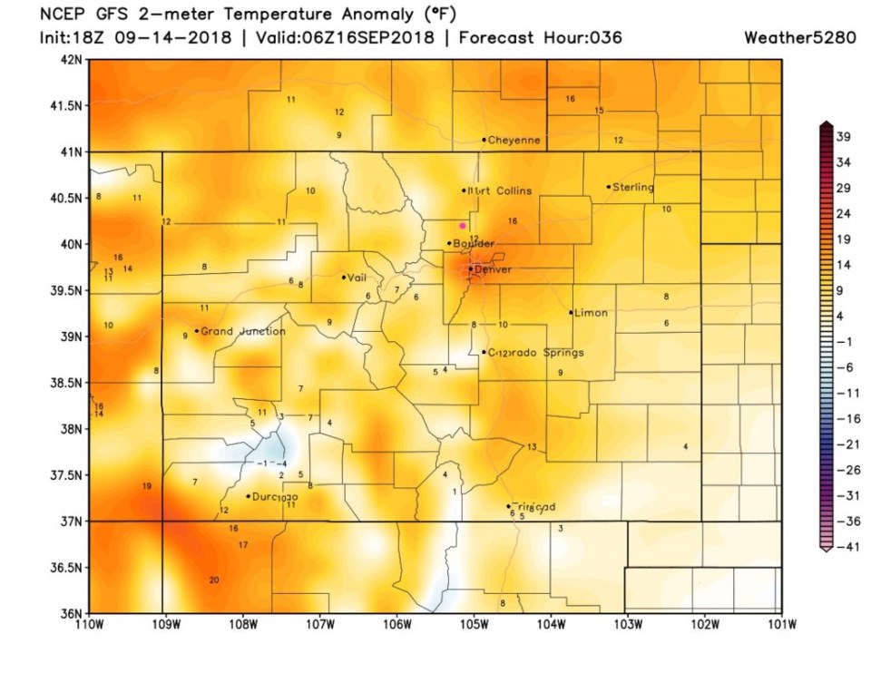
Figure 1 shows that with the upper air ridge (shown for many days now) and the surface high (shown for as many days) still in place, we warm up to record levels again this afternoon.  Temperatures are 10 to 15 degrees above normal for today (82F).

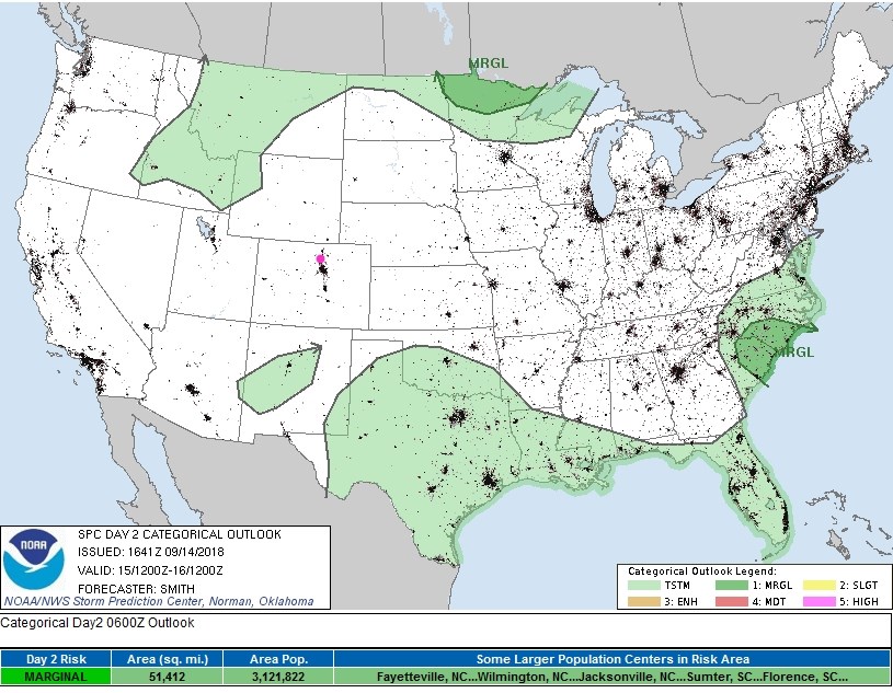
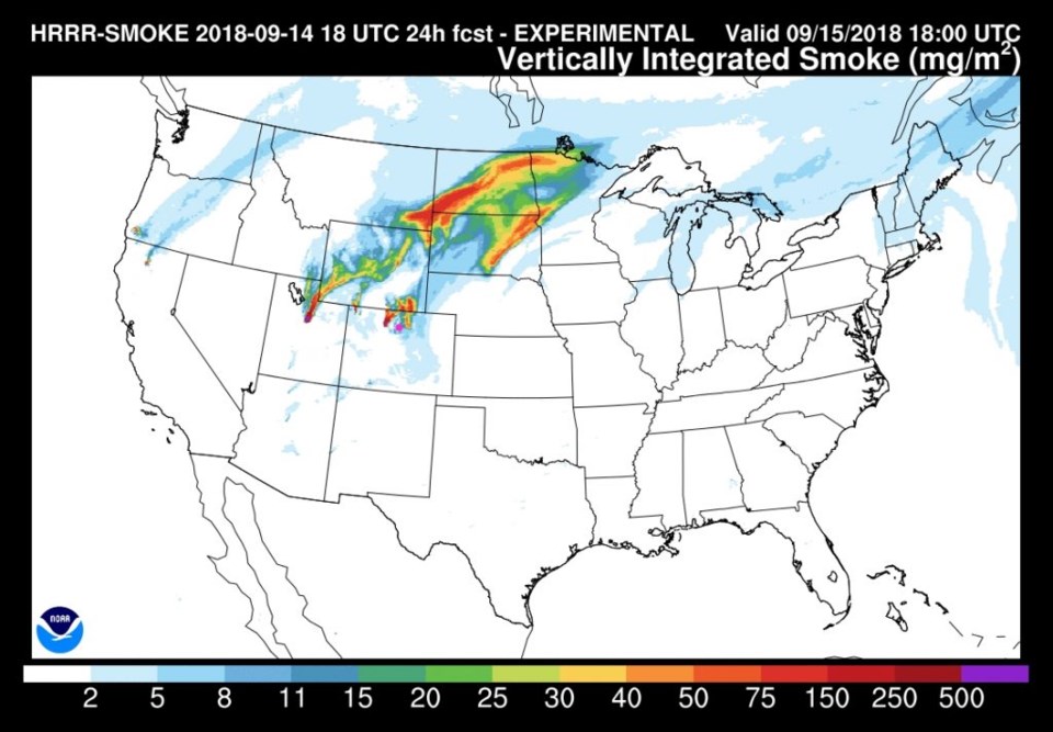
We again have no chance of convection/thunderstorms today (Figure 2). It will be just dry, clear, and smoky at times. Figure 3 shows the smoke from local Colorado fires getting pulled back around to this side of the Rockies at times.  I saw some of it up in the distance north at sunset Friday PM.

Figure 1: the departure from normal temperature afternoon Saturday- surface temperatures from weather5280.com

Figure 5: the day 2 SPC thunderstorm and severe weather forecast made Friday (valid Saturday).

Figure 3: The HRRR (high resolution rapid refresh) model forecast of smoke at all levels for Saturday PM.

The longer range forecast:

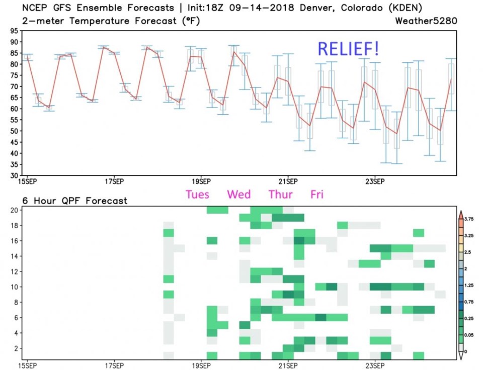
We stay hot, dry, and smoky at times through Monday.  Then the winds of change approach as the western trough begins to make inroads towards us.  There might be some tropical moisture entrained into the flow as well from the eastern Pacific. Figure 4 is the GFS meteogram out 10 days.  Tuesday on into Wednesday, temperatures drop to below normal and 'some' rain chances return (scattered rain chances, at least).

Figure 4: the GFS temperature and ensemble precipitation meteogram forecast for the next 10 days from weather5280.com

Current Weather

Light rain

Light rain

41°F

UV Index
2 Low
Pressure
29.91 Steady
Visibility
4 miles
Dewpoint
38 °F
Humidity
88%
Wind
N 4 mph
Gust
9.5 mph
Wind Chill
38 °F

Hourly Forecast

Today
1 PM
42°F
Rain
Today
2 PM
42°F
Cloudy
Today
3 PM
42°F
Rain
Today
4 PM
42°F
Cloudy
Today
5 PM
42°F
Cloudy
Today
6 PM
42°F
Rain and snow
Today
7 PM
41°F
Rain and snow
Today
8 PM
41°F
Rain
Today
9 PM
41°F
Cloudy
Today
10 PM
40°F
Rain
Today
11 PM
40°F
Rain
Tomorrow
12 AM
40°F
Rain

7 Day Forecast

Rain and snow

Saturday

42 °F

Chilly with a mix of snow and rain; travel in the foothills and mountains will be slippery due to snow


Rain and snow

Saturday Night

36 °F

Cloudy with rain, mixed with a little snow late; travel in the foothills and mountains will be slippery due to snow


Thunderstorms

Sunday

60 °F

Mostly cloudy and warmer; a thundershower in spots in the afternoon


Partly cloudy w/ t-storms

Sunday Night

37 °F

A thunderstorm in spots in the evening; otherwise, partly cloudy


Partly sunny

Monday

71 °F

Partly sunny, pleasant and warmer


Intermittent clouds

Monday Night

42 °F

Partly cloudy


Mostly sunny

Tuesday

73 °F

Mostly sunny; pleasant in the afternoon


Mostly cloudy

Tuesday Night

40 °F

Mostly cloudy


Intermittent clouds

Wednesday

65 °F

Times of sun and clouds with a passing shower in the afternoon


Rain

Wednesday Night

35 °F

Mainly clear


Sunrise and Sunset

Sunrise
6:04 AM
Sunset
7:52 PM

Based on AccuWeather data