Skip to content

The Next Storm/Next Snow Forecast Discussion from the Cherrywood Observatory – April 20, 2018

This content was originally published by the Longmont Observer and is licensed under a Creative Commons license.

Forecast Discussion:

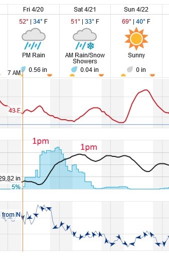
It is finally storm day!  Figure 1 is the next 3 days at-a-glance. A chance of rain begins around 7am but really picks up after noon.  The weatherunderground rainfall total (only a bit of snow possible Saturday AM - grassy surfaces and bridges might get a bit of slush) is about 2/3rds of an inch of liquid.

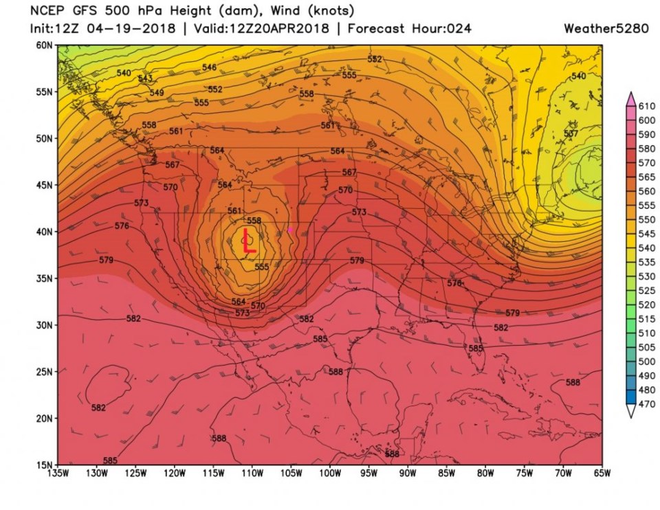
Figure 2 is the upper air cutoff low creating this storm.  It is fairly far north from optimal (for large rainfall and or snowfall amounts) Friday morning.

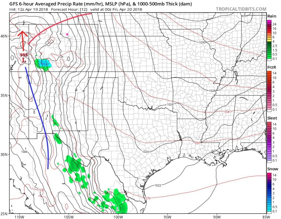
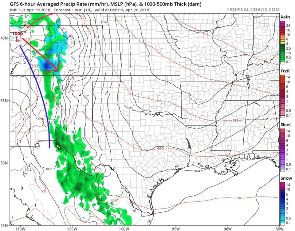
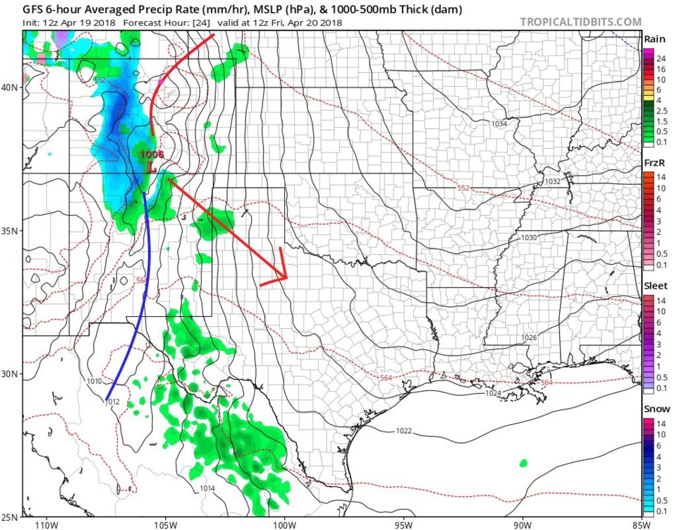
Figure 3-6 shows the surface low and approximate frontal positions as the storm passes. Figure 3, Thursday PM, the low is near the Four Corners. Instead of moving slowly eastward, it shoots north into NE Utah (Figure 4). Rainfall and snowfall hits the mountains and western slopes first (Thursday into Friday midnight).

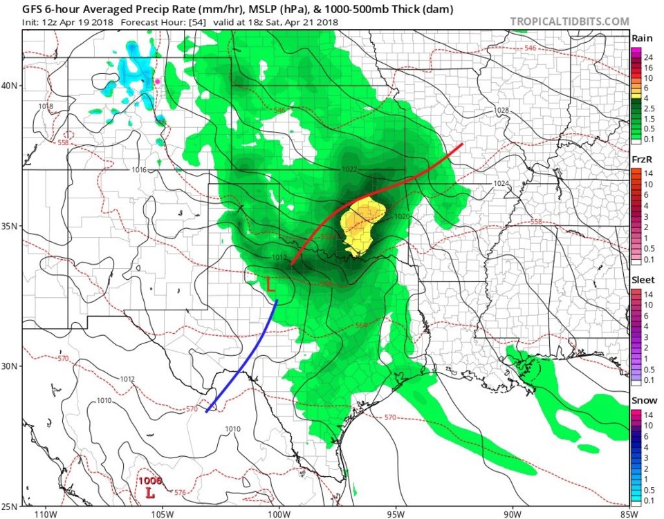
Figure 5 has the low back down where we want it, near Raton, and it is time for the mountain snows to really pick up and the Plains rain to begin (Friday 6am).  I'm skipping the bulk of the storm (lots of rain down low and snow up high) and jumping to the end of the storm around noon Saturday (Figure 6).  The low has continued southeast.

Precipitation forecasts by model:

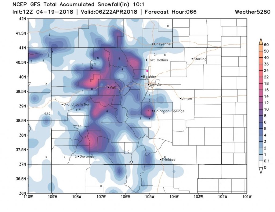
The GFS puts a trace/coating of snow on Lamont (more to the west) - Figure 7.

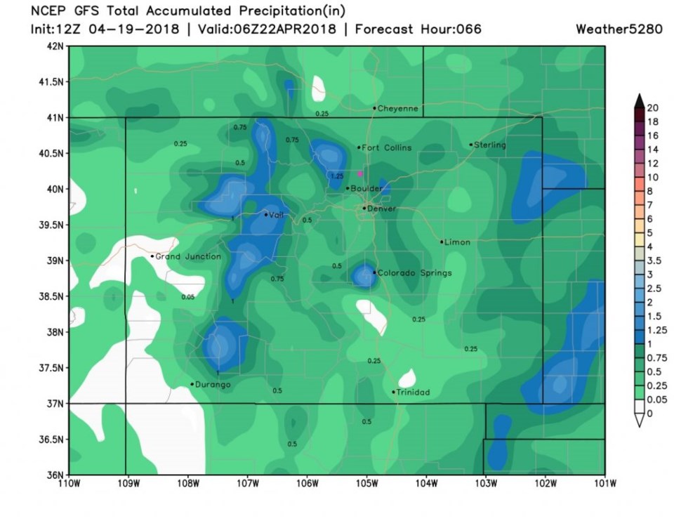
For total water, the GFS gives us 1/2 to 3/4th inchs of water - Figure 8.

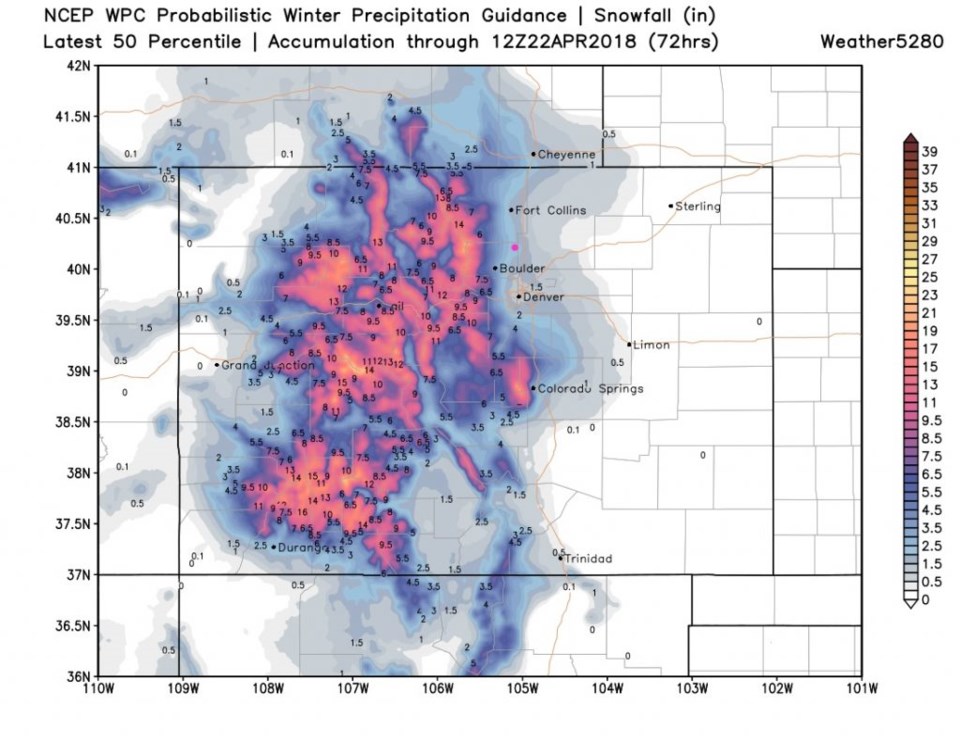
Figure 9 is the WPC 50th percentile confidence forecast - and we have a coating to an inch.  It could happen that Longmont gets a slushy inch if heavier precipitation hits us (that would cool the air column a bit more).

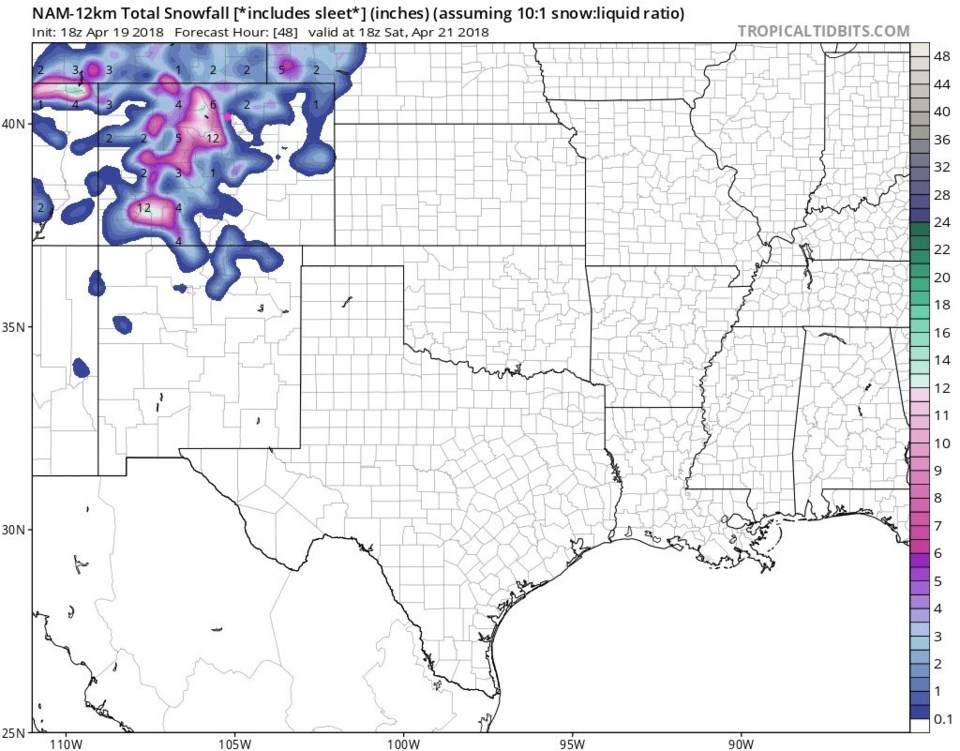
Figure 10 is the NAM and it has us on the edge of nothing to an inch of snow.

Aside from Saturday AM slush and grass-snow, this should be a nice wet Spring storm.

Figure 1: The next three days on the 10 day graphical forecast from weatherunderground.com

Figure 2: The 500mb map for 6am Friday. Low position in eastern central Utah is shown.

Figure 3: The surface analysis forecast for Thursday PM from the GFS and weather5280.com. Red arrow shows where surface low center moves in the next frame.

Figure 4: The surface analysis forecast for Friday midnight from the GFS and weather5280.com. Red arrow shows where surface low center moves in the next frame.

Figure 5: The surface analysis forecast for Friday 6am from the GFS and weather5280.com. Red arrow shows where surface low center moves in the next frame.

Figure 6: The surface analysis forecast for Saturday noon from the GFS and weather5280.com.

Figure 7: the GFS total snowfall accumulation forecast between Thursday PM and midnight Sunday AM from weather5280.com

Figure 8: the GFS total precipitation accumulation forecast between Thursday PM and midnight Sunday AM from weather5280.com

Figure 9: the WPC model 50th percentile confidence total snowfall accumulation forecast between Thursday PM and Sunday 6 AM from weather5280.com

Figure 10: the NAM total snowfall accumulation forecast between Thursday PM and Saturday noon from tropicaltidbits.com

The longer range forecast:

We warm right back up on Sunday (Figure 1 again). A Monday night storm may give us a bit of rain and a Tuesday cool down.  Nothing notable.  More later!

Current Weather

Clear

Clear

44°F

UV Index
0 Low
Pressure
29.86 Falling
Visibility
8 miles
Dewpoint
35 °F
Humidity
70%
Wind
NNW 2.2 mph
Gust
5.2 mph
Wind Chill
44 °F

Hourly Forecast

Today
4 AM
42°F
Mostly clear
Today
5 AM
40°F
Mostly clear
Today
6 AM
39°F
Mostly sunny
Today
7 AM
42°F
Mostly sunny
Today
8 AM
47°F
Partly sunny
Today
9 AM
52°F
Partly sunny
Today
10 AM
57°F
Intermittent clouds
Today
11 AM
62°F
Mostly cloudy
Today
12 PM
65°F
Cloudy
Today
1 PM
69°F
Cloudy
Today
2 PM
73°F
Cloudy
Today
3 PM
75°F
Cloudy

7 Day Forecast

Intermittent clouds

Saturday

64 °F

Cooler with clouds giving way to some sun


Mostly clear

Saturday Night

39 °F

Clear to partly cloudy


Mostly cloudy

Sunday

77 °F

Rather cloudy and warmer; breezy this afternoon


Mostly cloudy

Sunday Night

48 °F

Cloudy most of the time


Windy

Monday

57 °F

Winds gusting past 40 mph; cloudy and cooler


Intermittent clouds

Monday Night

43 °F

Partly cloudy


Intermittent clouds

Tuesday

59 °F

Windy and cool with times of clouds and sun


Partly cloudy

Tuesday Night

32 °F

Partly cloudy


Intermittent clouds

Wednesday

60 °F

Times of clouds and sun


Intermittent clouds

Wednesday Night

35 °F

Partly cloudy


Sunrise and Sunset

Sunrise
5:55 AM
Sunset
7:59 PM

Based on AccuWeather data