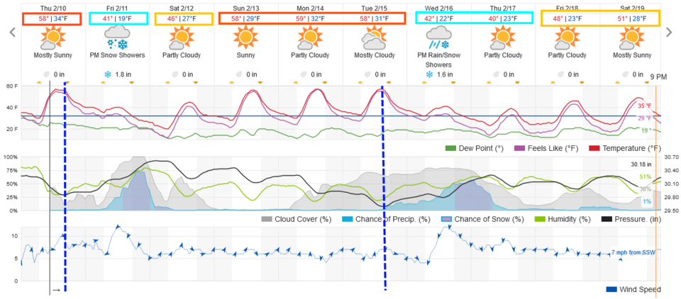
Skip to content
Join our Newsletter

Thursday Update: The Front Range Forecast: Warm & Dry // Cold with Snow

Thursday update:

A couple of snow chances return to the Front Range (Figure 1 update).These come with a couple of cold fronts, the first on Thursday, the next on Tuesday.

The first system is smaller short wave in the upper atmosphere and fast moving.  Still, we will see a period of falling snow from roughly 2 to 10 p.m. Friday.  I'm calling for 1-3 inches along and just west of I-25. Locations in the mountains or out on the plains will only see a dusting to an inch.

The next system is more speculative, but the short wave trough behind it is bigger/stronger. There is a potential for some locations to see 4-6" (as it looks now) with most areas getting 2-4".  

Interestingly- we see temperatures up to 15 degrees above normal between the storms. Enjoy that melting. As for the snow- I'll keep you up to date here! 


Figure1u_02102022
Figure 1 update: the 10 day graphical forecast for Denver from weatherunderground.com


About the Author: John Ensworth

John Ensworth used to work from Longmont as the PI for the NASA through the IGES (The Institute for Global Environmental Strategies). He now teaches technology, algebra, astronomy, meteorology, film school, and Lego robotics to middle/high school.
Read more


Comments


Current Weather

Mostly sunny

Mostly sunny

81°F

UV Index
5 Moderate
Pressure
30.13 Falling
Visibility
8 miles
Dewpoint
59 °F
Humidity
47%
Wind
NE 2.2 mph
Gust
4.9 mph
Wind Chill
81 °F

Hourly Forecast

Today
4 PM
83°F
Mostly cloudy w/ showers
Today
5 PM
84°F
Intermittent clouds
Today
6 PM
82°F
Intermittent clouds
Today
7 PM
79°F
Intermittent clouds
Today
8 PM
79°F
Intermittent clouds
Today
9 PM
76°F
Partly cloudy
Today
10 PM
72°F
Partly cloudy
Today
11 PM
69°F
Intermittent clouds
Tomorrow
12 AM
67°F
Intermittent clouds
Tomorrow
1 AM
65°F
Partly cloudy
Tomorrow
2 AM
64°F
Mostly clear
Tomorrow
3 AM
63°F
Clear

7 Day Forecast

Mostly cloudy w/ showers

Saturday

84 °F

Clouds and breaks of sun with a shower in places this afternoon; high levels of ozone will lead to poor air quality


Partly cloudy

Saturday Night

58 °F

Partly cloudy


Partly sunny w/ showers

Sunday

94 °F

Partly sunny with a passing shower in the afternoon


Partly cloudy

Sunday Night

61 °F

Partly cloudy


Mostly cloudy

Monday

94 °F

Considerable cloudiness


Mostly clear

Monday Night

60 °F

Clear to partly cloudy


Intermittent clouds

Tuesday

92 °F

Sun through high clouds


Partly cloudy

Tuesday Night

60 °F

Partly cloudy


Intermittent clouds

Wednesday

81 °F

Not as warm with times of clouds and sun; a thunderstorm in spots in the afternoon


Intermittent clouds

Wednesday Night

58 °F

An evening thunderstorm; otherwise, partly cloudy


Sunrise and Sunset

Sunrise
5:41 AM
Sunset
8:30 PM

Based on AccuWeather data