This content was originally published by the Longmont Observer and is licensed under a Creative Commons license.
By John Ensworth
Discussion:
Still our weather pattern is not changing, except the upper atmosphere is getting a bit drier. Figure 1 shows the dominate high pressure ridge to our west staying strong. The low over Houston (Tropical Storm Harvey) is spinning and dumping epic rainfall amounts along the eastern coast of Texas and into Louisiana. This evening, we finally have a hint that the storm may finally get moving to the north-north-east into Arkansas in the next 5 days in Figure 2 (still a long time and a slow progress!). This ridge will keep it quite dry (except in the mountains where widely scattered afternoon storms are possible) with near record heat for early September setting in. Note, the all-time highest temperature for September is 97F. The first snow ever seen at DIA is September 3rd, 1961. That record won’t be broken this year.
Figure 1: The 500mb RAP forecast initiation. Dry air flow an orange arrow. Extreme moisture flow in green.

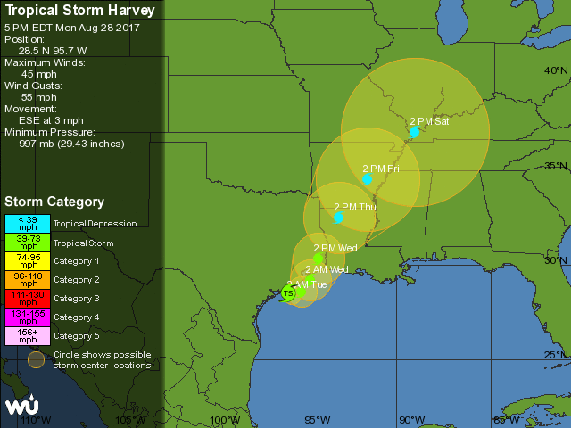
Figure 2: The National Hurricane Forecast Center 5 day forecast for (currently) Tropical Storm Harvey from weatherunderground.com.

In a look at the longer range:
The total accumulated precipitation between Monday PM and Tuesday Sept 5th is shown in Figure 3. Longmont looks to only have a few sprinkles now and then. The Gulf Coast has many oranges to yellows plotted predicting 10-24 inches more rain. New Orleans is not left out of the deluge for long. The pattern Saturday over Colorado and Longmont has not changed from Monday night in any notable way, but you can see the remains of Harvey are predicted to have moved up to Arkansas and Missouri on its way into the jet stream flow.
Figure 3: The GFS forecasted total rainfall between Monday PM to Tuesday September 5th from tropicaltidbits.com.

Figure 4: The GFS forecasted 500mb upper air analysis for Saturday AM.

*** This feature will run as close to daily as possible in this location on the Longmont Observer. ***
This article will provide a brief discussion concerning the ‘why’ behind the weather with a focus on severe weather, unusual weather, and snow (especially trying to predict snow depth and its human impact in Longmont).
Bio:
John Ensworth works from Longmont as the Principle Investigator for the NASA Science Mission Directorate Earth and space science education product review through the IGES (The Institute for Global Environmental Strategies – www.strategies.org) . He is in his 14th year running this review. He is an astronomer (from the 2nd grade onward) and became a meteorologist (in the 5th grade) when a thunderstorm in Arizona rained on his telescope when the weather service had only forecasted a 10% chance of rain. He has college degrees in physics and astronomy and climatology and a graduate degree in meteorology and earth science. He lectures at the Little Thompson Observatory in Berthoud, the Estes Park Memorial Observatory in Estes Park, and for a number of online universities. He built and runs a backyard observatory near Pace and 17th in northeast Longmont where he has lived for 8 years with his wife, daughter, son, and two cats. Invitations to open house nights at this observatory, LTO, and EPMO will be posted with future discussions when they are scheduled.
Forecasting severe weather and snow amounts via text lead to this column. He began texting friends about the weather right after the September 2013 flood. The readers of this column will, hopefully, keep him honest in what he ‘thought’ he had forecasted for ‘the most recent’ storm.


