Skip to content
Join our Newsletter

Tuesday Update: The Front Range Forecast: A "warm" winter storm arrives (Winter Storm Watch for some.)

Figure2u_03152022
Figure 2: the 3 day snowfall total (10:1) from the GFS and weather5280.com

The Tuesday Update:

First, lets start with the NWS and the winter storm watch for areas west of I-25 and running from Berthoud down to the Palmer Divide (only western Denver, for example).

Winter Storm Watch
Issued: 2:54 PM Mar. 15, 2022 – National Weather Service

...WINTER STORM WATCH IN EFFECT FROM WEDNESDAY EVENING THROUGH
THURSDAY AFTERNOON...

* WHAT...Heavy snow possible. Total snow accumulations between 4 and 10 inches, with heavier totals possible across the higher
elevations.

* WHERE...The Southern Front Range Foothills, Boulder and the western suburbs of Denver, and Castle Rock.

* WHEN...From Wednesday evening through Thursday afternoon.

* IMPACTS...Roads will likely become slick and hazardous. Travel could be difficult during the Thursday morning commute.

PRECAUTIONARY/PREPAREDNESS ACTIONS...

Roads will be slick resulting in slow and hazardous travel. Allow extra time to reach your destination.

Chain and traction laws will possibly be enacted for the mountains. If travelling to the mountains, be prepared for winter driving
conditions.

______________________________________________________________________

Temperatures with this system will be marginal, but expected moisture is higher than we saw five days ago. 

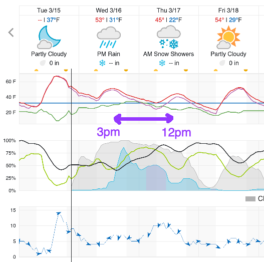
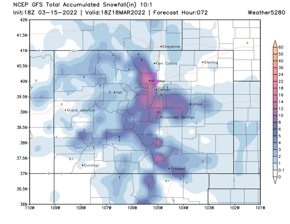
Precipitation will start in the late morning in the mountains and around 3 p.m. Wednesday.  Precipitation chances drop after noon on Thursday (Figure 1 update). Figure 2 update shows how little snow will fall east of I-25, but by the time one gets to Boulder, you are up to a few inches.

I'm expecting Fort Collins to Loveland to get 0-2 inches.  Berthoud to Broomfield getting 1-4 inches. Lyons to Boulder to Golden  2-5 inches. Estes Park 3-6 inches.  The Denver International Airport is in the 1-4 inches range. With rain at the start of the storm and warm ground, the best amounts will build up on cool/grassy surfaces. (I'm calling for less accumulation than the NWS.)

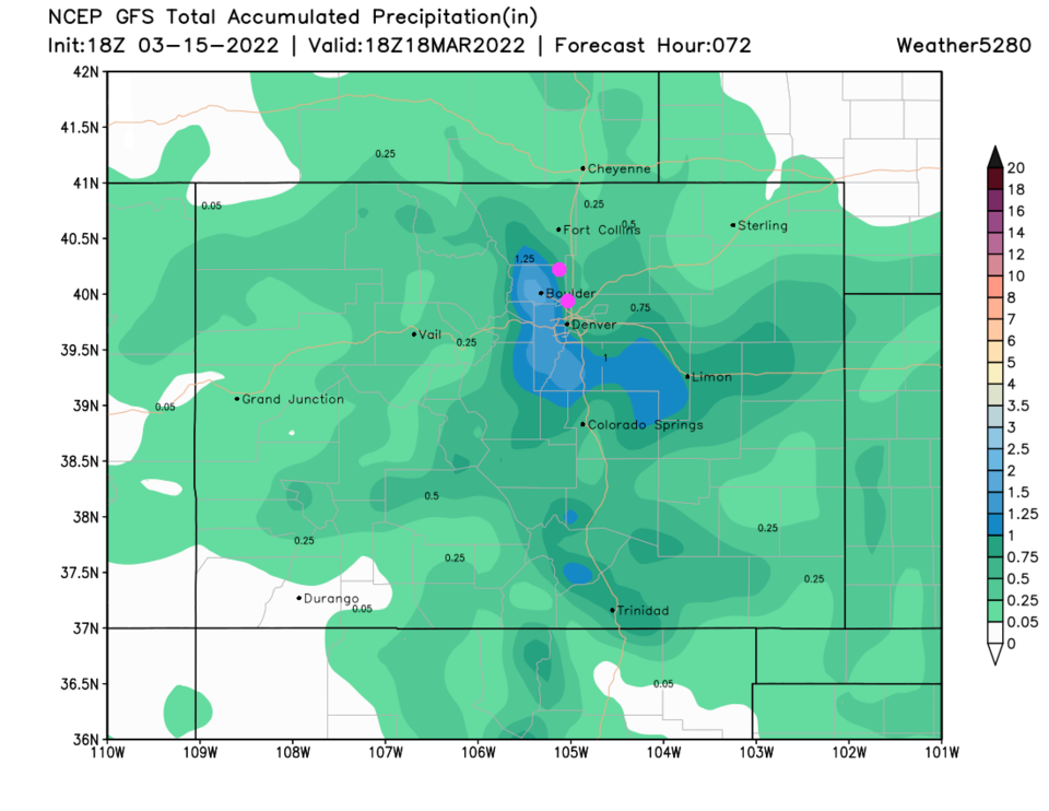
As for rainfall, we see about 1/5th inch in Ft. Collins increasing to 3/4th inch of water above Boulder (this model OVERDOES liquid precipitation).


Figure1u_03152022
Figure 1 update: snippet of the 10 day graphical forecast for Denver from weatherunderground.com
Figure2u_03152022
Figure 2: the 3 day snowfall total (10:1) from the GFS and weather5280.com
Figure3u_03152022
Figure 3: the precipitation from the GFS and weather5280.com


About the Author: John Ensworth

John Ensworth used to work from Longmont as the PI for the NASA through the IGES (The Institute for Global Environmental Strategies). He now teaches technology, algebra, astronomy, meteorology, film school, and Lego robotics to middle/high school.
Read more


Comments


Current Weather

Mostly cloudy

Mostly cloudy

69°F

UV Index
0 Low
Pressure
30.08 Falling
Visibility
8 miles
Dewpoint
65 °F
Humidity
87%
Wind
SW 2.7 mph
Gust
5.3 mph
Wind Chill
69 °F

Hourly Forecast

Today
8 PM
66°F
Thunderstorms
Today
9 PM
66°F
Cloudy
Today
10 PM
66°F
Partly cloudy
Today
11 PM
65°F
Partly cloudy
Tomorrow
12 AM
64°F
Partly cloudy
Tomorrow
1 AM
64°F
Partly cloudy
Tomorrow
2 AM
63°F
Partly cloudy
Tomorrow
3 AM
62°F
Partly cloudy
Tomorrow
4 AM
61°F
Partly cloudy
Tomorrow
5 AM
59°F
Partly cloudy
Tomorrow
6 AM
60°F
Mostly sunny
Tomorrow
7 AM
61°F
Mostly sunny

7 Day Forecast

Partly sunny w/ t-storms

Tuesday

79 °F

A morning shower; otherwise, some sun; a few t-storms, some severe this afternoon; storms can bring flash flooding, hail, damaging winds, and even a tornado


Partly cloudy w/ t-storms

Tuesday Night

59 °F

A thunderstorm in spots early this evening; otherwise, partly cloudy


Partly sunny w/ t-storms

Wednesday

79 °F

Intervals of clouds and sunshine with a thunderstorm in the afternoon


Mostly clear

Wednesday Night

55 °F

Clear to partly cloudy


Partly sunny

Thursday

89 °F

Partly sunny and pleasant


Clear

Thursday Night

55 °F

Clear


Mostly sunny

Friday

94 °F

Mostly sunny and very warm


Clear

Friday Night

57 °F

Clear


Mostly sunny

Saturday

94 °F

Sunny to partly cloudy and very warm


Mostly clear

Saturday Night

56 °F

Mainly clear


Sunrise and Sunset

Sunrise
5:32 AM
Sunset
8:34 PM

Based on AccuWeather data