Skip to content
Join our Newsletter

Tuesday Update: Winter Storm Watch/Snowfall Roundup

Winter Storm Watch

Figure1u_02152022
Figure 1 update: the winter storm watch regions from the NWS.
Issued: 7:42 PM Feb. 15, 2022 – National Weather Service

...WINTER STORM WATCH REMAINS IN EFFECT FROM WEDNESDAY AFTERNOON
THROUGH LATE WEDNESDAY NIGHT... (Figure 1 update above)

* WHAT...Heavy snow possible. Total snow accumulations between 4 and
8 inches possible, with locally heavier amounts in the foothills.

* WHERE...The Front Range Foothills and I-25 Corridor.

* WHEN...From Wednesday afternoon through late Wednesday night.

* IMPACTS...Travel could be difficult. The hazardous conditions
could impact the Wednesday evening commute.

PRECAUTIONARY/PREPAREDNESS ACTIONS...

Monitor the latest forecasts for updates on this situation.

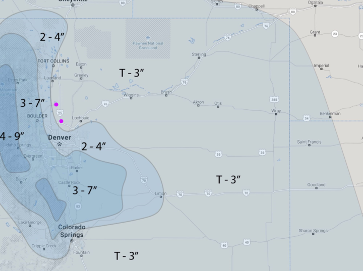
Snowfall Roundup (Longmont to Broomfield):

The storm should begin around 12-1pm Wednesday with snow tapering off around 1-2am Thursday.  The peak snowfall rates should be during the evening commute Wednesday

John E:  2-4 inches.

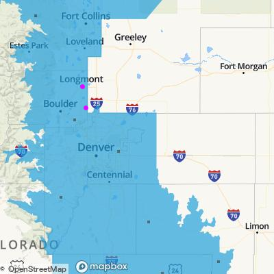
Weather5280 (Figure 2 update) Trace-3 inches.

The NWS:  4-8 inches (it seems)

The GFS 4-6 inches

The NAM 3-5 inches

The Canadian model:  4-6 inches

Accuweather: 3-6 inches

Channel 7 news:  5-7 inches

Channel 9 news:  4-8 inches

That is a fair amount of disagreement - we'll see how it plays out!


Figure2u_02152022
Figure 2 update: the hand drawn update for snow totals for our mid-week storm from the forecasters at weather5280.com


About the Author: John Ensworth

John Ensworth used to work from Longmont as the PI for the NASA through the IGES (The Institute for Global Environmental Strategies). He now teaches technology, algebra, astronomy, meteorology, film school, and Lego robotics to middle/high school.
Read more


Comments


Current Weather

Light rain

Light rain

62°F

UV Index
0 Low
Pressure
29.9 Rising
Visibility
23 miles
Dewpoint
37 °F
Humidity
40%
Wind
NW 4.3 mph
Gust
12.4 mph
Wind Chill
62 °F

Hourly Forecast

Today
6 PM
60°F
Thunderstorms
Today
7 PM
58°F
Partly sunny
Today
8 PM
55°F
Rain
Today
9 PM
53°F
Rain
Today
10 PM
50°F
Rain
Today
11 PM
48°F
Rain
Tomorrow
12 AM
47°F
Rain
Tomorrow
1 AM
47°F
Cloudy
Tomorrow
2 AM
47°F
Rain
Tomorrow
3 AM
47°F
Rain
Tomorrow
4 AM
47°F
Rain
Tomorrow
5 AM
46°F
Rain

7 Day Forecast

Mostly cloudy w/ t-storms

Wednesday

71 °F

Turning cloudy; a thundershower in parts of the area this morning followed by thundershowers this afternoon


Rain

Wednesday Night

46 °F

Rain and drizzle


Partly sunny w/ showers

Thursday

59 °F

A touch of rain in the morning; otherwise, cooler with increasing amounts of sun


Partly cloudy w/ showers

Thursday Night

40 °F

A couple of showers in the evening; otherwise, partly cloudy


Mostly cloudy

Friday

68 °F

Mostly cloudy


Clear

Friday Night

38 °F

Clear


Mostly sunny

Saturday

77 °F

Mostly sunny, pleasant and warmer


Mostly clear

Saturday Night

41 °F

Mainly clear


Mostly cloudy

Sunday

74 °F

Sun followed by clouds; breezy in the afternoon


Intermittent clouds

Sunday Night

49 °F

Windy in the evening; becoming partly cloudy


Sunrise and Sunset

Sunrise
6:02 AM
Sunset
7:54 PM

Based on AccuWeather data