One year and seven months after the Cal-Wood fire burned through a beloved open space near Lyons, the biggest concern of the rest of Heil Valley Ranch reopens this summer is going to be flooding.
The Cal-Wood Fire broke out Oct. 17, 2020 near the Cal-Wood Environmental Center, burning six miles in just four hours. Totalling 16 square miles, it was the largest wildfire in Boulder County over the last century and burned 6,000 acres of Boulder County Parks and Open Space land, including much of Heil Valley Ranch.
The south section of Heil Valley Ranch will be reopening June 16, including Corral Trailhead, Main Trailhead, the southern section of the Wapiti Trail, the Lichen Loop, the Overland Trail, the Schoolhouse Loop and the Grindstone Quarry Trail.
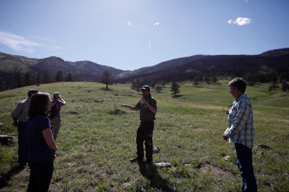
On Thursday, members of the public, elected officials, advisory committee members and Boulder County staff were the first to tour the area without having to wear hard hats.
The southern section of Heil Valley Ranch is no stranger to floods, having seen its main road washed out in the 2013 floods. Boulder County’s recovery work focused on stabilizing the burned slopes of the watershed and then stabilizing the creeks, while also updating and improving amenities.
Heil Valley Ranch Resident Ranger Kevin Grady explained that because of the burning, which destroyed the many plants and trees that kept sediment in place, a ten-year flood event could have the same effect as the 2013 flood, washing out the road and stranding recreationists and residents in the area, including himself.
That’s why the main trailhead parking lot at Heil Valley Ranch will only be open through noon this summer until the end of September.
“The threat of monsoonal rains — high intensity, short duration events happening during that time frame and usually in the afternoon — is what we based our decision for that closure on,” Grady said during the tour.
Ranger Bevin Carithers explained that with Boulder County emergency responders already stretched thin, this closure reduces the risk of having to rescue up to 60 stranded vehicles and hikers during a flash flood — while still keeping Heil Valley Ranch open to the public.
“That is our hope if we have that big afternoon flood event, we don’t have to worry about this parking lot,” Carithers said.
The noon closures will happen every day regardless of the weather that afternoon, and there will be signs and rangers out educating the public once the area reopens.
During the closure of Heil Valley Ranch, Boulder County landscape architect Bethani Puzo was able to go in and improve both the parking and drainage situation in the main parking lot.
“We are in a hole right here,” Puzo said, standing in the main lot’s picnic shelter. “All the water wants to flow here — that’s why it all flows here.”
Using new surveying equipment, Puzo and the county’s parks crew were able to improve the grade in the parking lot, add 13 parking spots and widen the road through, while standardizing stall sizes to 10 by 20 feet.
Rather than using wood timbers to line the spaces in the dirt lot, the county used local Lyons stone to provide a longer lasting barrier. The goal is that the majority of construction on the lot will be done by opening day, June 16, but a bridge will have to be replaced at the far end of the lot this winter so some parking stalls will be timber until that is complete.
While the parking lot improvements might be the most noticeable to visitors, county staff spent the last year conducting $5.7 million worth of restoration work focused on soil stabilization, erosion control and sediment capture. The Natural Resources Conservation Service’s Emergency Watershed Protection program funded 75% of that work, while Boulder County and the state covered the rest.
Overlooking the burned hillsides, Boulder County Senior Plant Ecologist David Hirt explained how the county mulched 1,843 acres of open space using 9,343 tons of mulch last summer.
“Research over the last few decades has really shown the best, most immediate thing you can do post-fire recovery is to get cover on the bare soil,” he said. “The best way to do that is with mulch.”
Given that the two biggest wildfires in state history burned around the same time as the Cal-Wood fire, mulch was in high demand. The mulch for Heil Valley was sourced from the many dead and burned trees already on property, which was a novel approach, according to Boulder County Forestry and Biomass Resource Specialist Scott Golden.
“It would’ve taken us about 500 semi loads (of mulch) just to do our property,” Golden said. “That was the year of the Cameron Peak, the (East) Troublesome — everybody was wanting mulch. No one’s really done that before. I actually think that’s going to be a little bit of a paradigm shift, because it makes sense.”
Slopes between 20-60% grade were targeted, as flatter slopes don’t see the flooding and debris flow risks and mulch doesn’t stay put on steeper slopes.
Eight miles of roads and trails have been cleared of hazard trees, but visitors this summer will be asked to stay on marked trails in the burn scar for their own safety. County staff and volunteers have also planted 3,000 ponderosas so far along Lichen Loop and Wapiti Trails with another 1,000 planned.
Culverts have been strengthened, safety communications updated and weather forecasting on the burn area enhanced. There are still two trails in Heil Valley that cross a creek, but there’s a sign telling hikers not to cross in the case of flooding.
There are also two flood safety routes marked that hikers caught in a flash flood can follow to a safe area, where they are then instructed to wait and call 911. Grady said they will likely just have to stay there until the water subsides, which can take anywhere from 45 minutes to two hours.
Another change for the public come the June 16 opening includes a detour of Wapiti Trail, where golden eagles began nesting during the closure. Federal guidelines ask for a half-mile buffer zone between the golden eagle nest sites and areas of human activity.

