Skip to content

Next Storm/Next Snow Forecast Discussion from the Cherrywood Observatory – July 2, 2019

This content was originally published by the Longmont Observer and is licensed under a Creative Commons license.

In Brief:

We hover near 90F for four more days then hop around in the 80'sF more beyond that. There are daily chances of afternoon storms, but the severe storm possibility is still on the table for Longmont today (Tuesday).

Forecast Discussion:

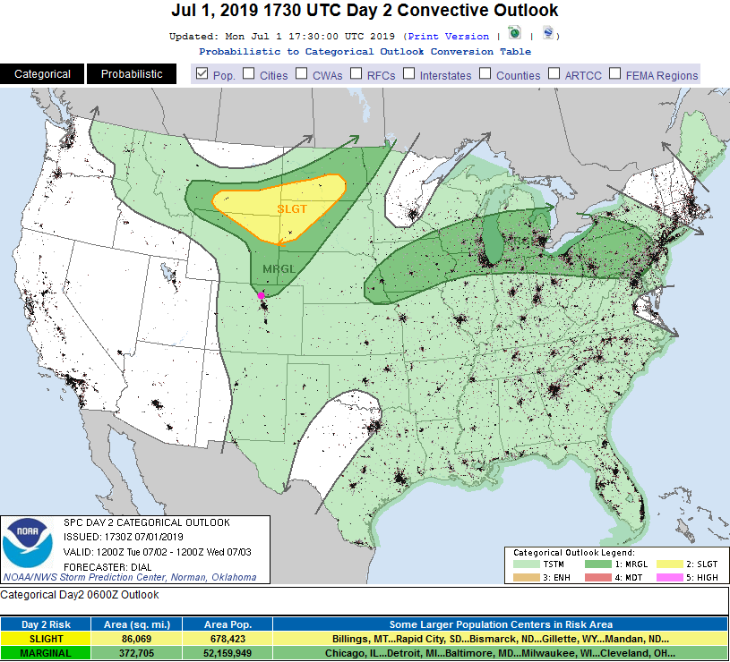
The moisture will be down just a bit today (Tuesday) but mountain thunderstorms moving east in the afternoon are to be expected again (Figure 1). The conditions for severe weather from roughly Longmont northward exist again for hail and high winds (Figure 2). If this gets redrawn in the morning, I'll update things here. We climb to the upper 80'sF before the clouds and showers move in.

The Longer Range Forecast:

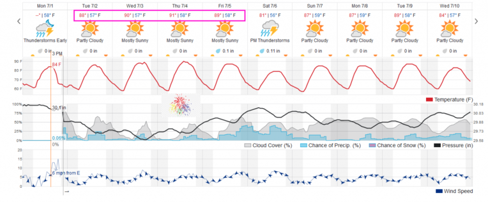
We have about 4 days straight with highs hovering near 90F through Friday - then we drop to the lower 80'sF for a day Saturday (Figure 3).

The 4th of July Forecast:

It is looking more like a day with a high at 90F and a low at 58F. At 9pm, when fireworks are about to begin, we should have cooled to 75F with a chance of mosquitoes and 10% chance of remaining showers (Figure 3).

The Longer Longer Range Forecast:

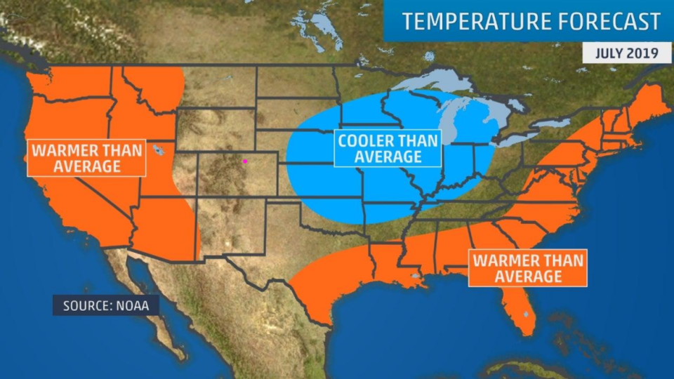
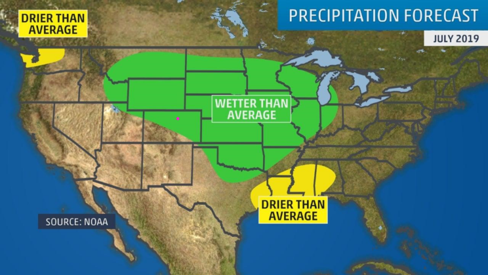
Glancing ahead to the entirety of July, the weather channel is predicting normal temperatures (Figure 4) and above normal precipitation (Figure 5). The European model (not shown) has us much wetter than normal and below normal as temperatures go (sounds like the July version of June!).

We'll see!

Figure 1: The forecast surface map for Tuesday night from NCEP.
Figure 2 The severe storm weather forecast for the U.S. from the Storm Predication Center in Norman, OK. Made Monday for Tuesday.
Figure 3: the graphical forecast for the next 10 days for Longmont, CO from weatherunderground.com
Figure 4: The July temperature outlook for the U.S. from weather.com
Figure 5: The July precipitation outlook for the U.S. from weather.com

Current Weather

Mostly cloudy

Mostly cloudy

70°F

UV Index
0 Low
Pressure
29.98 Falling
Visibility
8 miles
Dewpoint
41 °F
Humidity
34%
Wind
WSW 4.9 mph
Gust
11.1 mph
Wind Chill
70 °F

Hourly Forecast

Today
8 PM
68°F
Showers
Today
9 PM
64°F
Showers
Today
10 PM
61°F
Partly cloudy
Today
11 PM
59°F
Partly cloudy
Tomorrow
12 AM
58°F
Partly cloudy
Tomorrow
1 AM
57°F
Partly cloudy
Tomorrow
2 AM
55°F
Partly cloudy
Tomorrow
3 AM
54°F
Partly cloudy
Tomorrow
4 AM
52°F
Partly cloudy
Tomorrow
5 AM
51°F
Partly cloudy
Tomorrow
6 AM
50°F
Partly sunny
Tomorrow
7 AM
53°F
Partly sunny

7 Day Forecast

Mostly cloudy w/ t-storms

Saturday

77 °F

Increasing cloudiness and not as warm


Partly cloudy

Saturday Night

50 °F

Partly cloudy


Mostly sunny

Sunday

81 °F

Sunshine and patchy clouds; breezy in the afternoon


Mostly clear

Sunday Night

49 °F

Mainly clear


Partly sunny w/ t-storms

Monday

70 °F

Not as warm with times of sun and clouds; a thunderstorm in spots in the afternoon


Thunderstorms

Monday Night

46 °F

Cloudy with a couple of thundershowers


Thunderstorms

Tuesday

60 °F

Mostly cloudy and cooler; a couple of afternoon showers and a thunderstorm


Intermittent clouds

Tuesday Night

37 °F

Partly cloudy


Partly sunny

Wednesday

73 °F

Pleasant and warmer with partial sunshine


Mostly clear

Wednesday Night

40 °F

Mainly clear


Sunrise and Sunset

Sunrise
5:41 AM
Sunset
8:13 PM

Based on AccuWeather data