This content was originally published by the Longmont Observer and is licensed under a Creative Commons license.
In Brief:
A beautiful Friday and even better Saturday (70F for a high) will be dramatically changed by a major winter storm Saturday night. The cold front will hit around sunset Saturday with heavy snow starting around midnight. We will now have about 120 hours of below freezing temperatures (Sunday midnight to Friday late morning). Forecasts vary, but about 5-8 inches of snow (locally up to 10 inches) seems likely over the Sunday-Wednesday stretch. The second surge of cold air and snow is not clearly handled by the models yet.
Forecast Discussion:
First - We'll have the NWS talk:
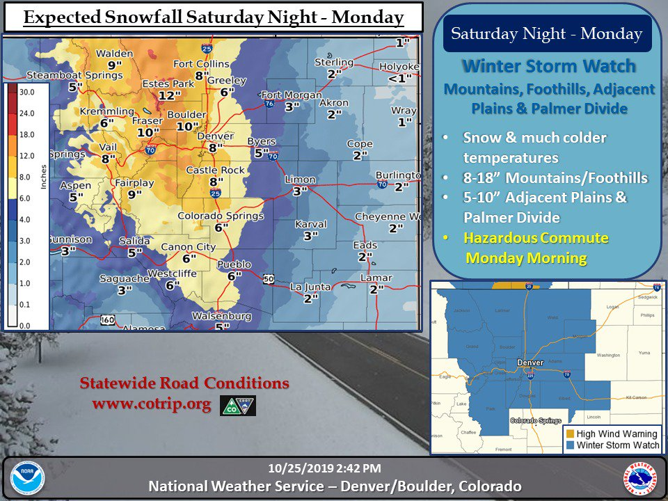
Winter Storm Watch issued October 25 at 1:52PM MDT until October 28 at 6:00PM MDT by NWS Denver CO...HEAVY SNOW POSSIBLE SATURDAY NIGHT THROUGH MONDAY... .Snow will develop over the northern mountains and plains Saturday night and will progress southeastward. The plains and urban corridor will see freezing drizzle early Sunday morning which will make roads icy and hazardous. Precipitation will switch to snow during the mid morning Sunday with light to moderate snow rates expected through the day. The snow may be heavy at times Sunday night and Monday morning before tapering off Monday afternoon. Hazardous road conditions are expected to develop with the worst conditions during the Monday morning rush hour.
* WHAT...Heavy snow possible. Total snow accumulations of 5 to 10 inches possible.
* WHERE...Denver [up to] Fort Collins [and] east to Limon and Greeley.
* WHEN...From late Saturday night through Monday afternoon.
* IMPACTS...Travel could be very difficult. The worst conditions will be during the Monday morning commute.
* ADDITIONAL DETAILS...Freezing drizzle Sunday morning will make roads icy.
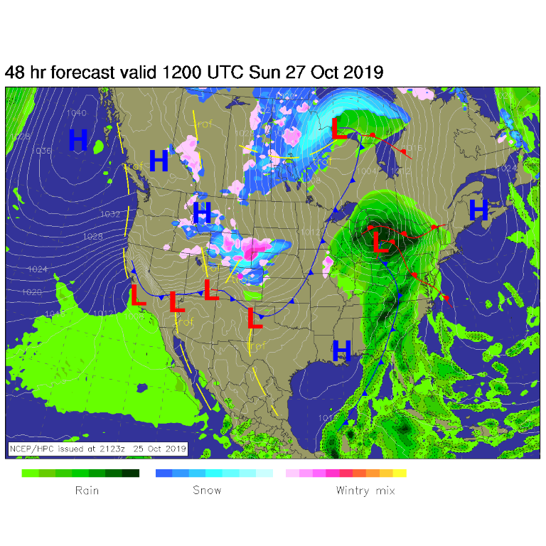
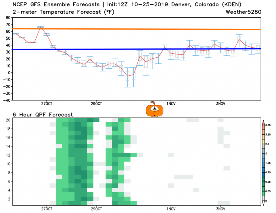
After excessive niceness created by a departing upper level ridge and warm down slope flow on Saturday, the cold front arrives around sunset (Figure 4 dashed blue line). By Sunday morning, it is mostly south of the state already with snow picking up rapidly with strong up slope flow (Figure 1) over northern Colorado.
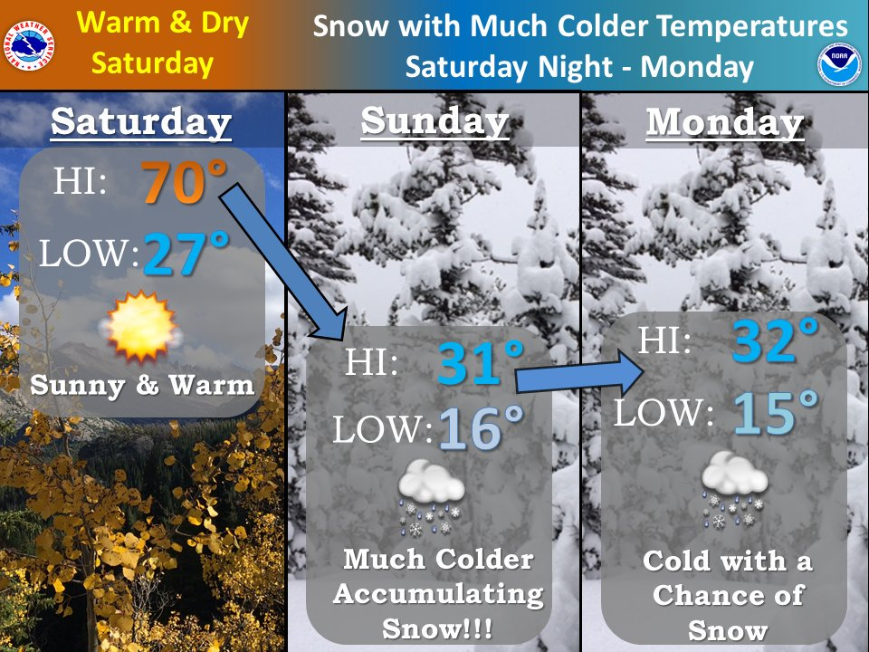
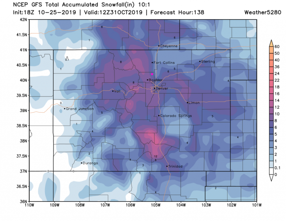
The NWS in Boulder wants to further illustrate the big temperature drop and arriving snow in Figure 2. Their take on the snowfall gives us up to 8 inches between late night Saturday and Monday (Figure 3) - locally 10 inches just by Monday by the verbiage in the winter storm watch.
The Longer Range Forecast:
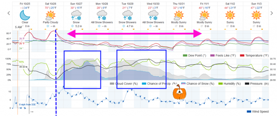
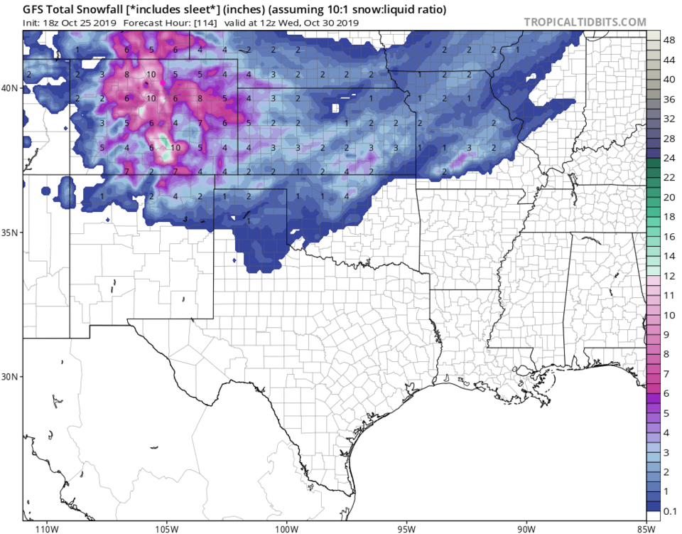
This storm stretches off into the longer range as well. Figure 4 and 5 show that there will be two main impulses of snow Sunday into Monday (the main focus by the NWS right now) and another on Tuesday into Wednesday.
The NWS places us in the 6-8 inch zone through Monday. Weatherunderground (Figure 4) gives us 5-6 inches into Monday and another 4-5 inches Tuesday/Wednesday.
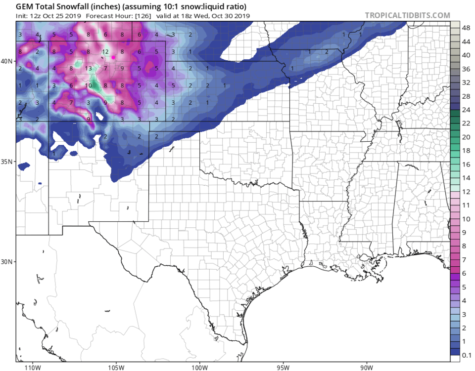
The GFS (Figure 6 and 7 for a wider view) places us in the 5-6 inch zone for both impulses. The GEM (Figure 8) gives us 5-7 inches for both storms components.
Also notable will be prolonged freeze. We will be below freezing (except maybe briefly on Halloween) from Sunday early morning to Friday morning. This is about 120 hours of chill (pink arrow Figure 4). I've drawn the freezing line (blue) on the GFS output in Figure 5. The approximate normal high temperature for this time of year is the orange line up on top. We break above normal only briefly Saturday.
The Halloween Forecast:
It is looking scarier. We had a LOT of model disagreement yesterday, but they are all trending towards the colder European solution. With clouds clearing (still good news for Trick or Treat-ers and my Observatory) it looks cold. Weatherunderground gives us a high of 32F and a low of 16F. The European warmed a bit to a high of 19F and a low of 4F. The GFS is about 31F with a low of 22F. BRRRRRRR!